Major crisis management and emergency exercises are an essential part of disaster response preparation for organisations, covering scenarios including fire and explosions, gas pipelines, health issues and national events.
Major disasters can happen at sea, and they require a massive response. A benchmark exercise in Western Australia demonstrated the power and capabilities of a platform powered by ArcGIS to create a common operating picture, enabling faster and more intelligent response and recovery.
Running over four days in September 2017, Western Australia Department of Transport’s Exercise Ningaloo Challenge was the largest-ever offshore emergency exercise undertaken in Australia.
Managed by the Marine Safety Business Unit, the exercise involved more than 300 personnel, 16 oil companies, nine Western Australia state government agencies and 11 Commonwealth agencies.
The scenario for Exercise Ningaloo Challenge was similar in part to the 2010 Deepwater Horizon oil spill – with total loss of well control and blow-out preventers failing resulting in uncontrolled flow of oil expected to last three months offshore, potentially polluting 1,800 km of West Australian coastline and 300 islands, from Exmouth south to Geraldton.
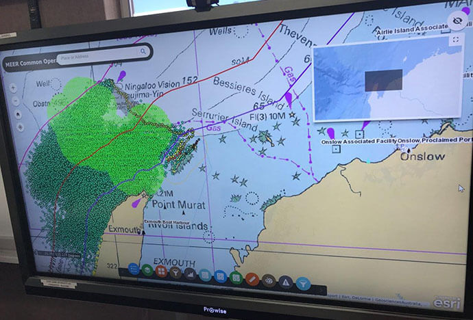
Central to the success of disaster planning, response, and recovery is the capability of GIS technology to manage, share and analyse real-time data to provide a common operating picture.
Throughout Exercise Ningaloo Challenge, every screen in the command centre displayed a common operating picture running on ArcGIS Enterprise (Portal) with live feeds via GeoEvent Server. During the previous year’s exercise, teams relied on printed maps and struggled to keep up with real-time updates.
In 2017, the deployment of ArcGIS enabled the rapid sharing of information to all participants in near-real time via interactive touch screens – placing the information that was needed in the hands of decision makers.
In addition, Shoreline Assessment Teams (SATs) used ArcGIS field applications to fed information, including photos, back to the Perth office, some 1,200 km away.
The exercise involved people going into the field and simulating a response to the disaster – even down to running daily simulated press conferences, involving participants including senior members of the commercial organisations and senior government representatives, such as the State Marine Pollution Coordinator, the State Disaster Recovery Coordinator and a Petroleum Title Holder CEO.
The capabilities of ArcGIS allow all disaster response and recovery teams to see the same data at the same time, from inside a command centre or in the field.
The value of a common operating picture with focused apps for each part of the response can help save lives, property and money, expediting clean up and recovery operations.
This exercise was the first real business focused use of ArcGIS Enterprise (Portal) for the Department of Transport’s GIS team and the positive feedback and reduced workload has validated the decision to move to delivering a digital platform to support the department’s activities. We look forward to seeing how much further the use of the ArcGIS platform can support the department in the future.
To find out how ArcGIS can help provide a common operating picture for recovery and response, call us on 1800 870 750 or send us an email.
Banner image credit: NOAA Office of Response and Restoration