

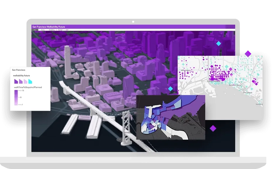
ArcGIS products give you access to APIs, location services, and tools to develop your own mapping and spatial analysis applications. Build web, native, offline, desktop, or integrated solutions for yourself, your organisation, or other organisations. Access a full suite of location services to provide basemap layers, geocoding and routing capabilities, and other geospatial functionalities. Securely host and manage your data in the ArcGIS cloud.

High performance
GPU-accelerated drawing and client-side analytics

Easy to use
Integrate location services with minimal code

Private and secure
Store data in the cloud or behind the firewall

Affordable pricing
Start for free and pay as you go for other services


ArcGIS Location Platform
ArcGIS Location Platform is a platform as a service (PaaS) for developers for building mapping and analysis applications.
- Access location services (basemap layers, geocoding, routing, GeoEnrichment, spatial analysis and more)
- Build apps with web, native, scripting, and open-source APIs for JavaScript, iOS, Android, .NET, Java, Qt and Python
- Securely create, store, and share content and data
- Automate administration, mapping and analysis tasks
- Leverage mapping, analysis, and developer tools to manage maps, layers and data
ArcGIS Online
ArcGIS Online is a software as a service (SaaS) offering that organisations can use to create, manage and share geospatial content in the cloud.
- Access location services
- Build apps with web, native, scripting, and open-source APIs for JavaScript, iOS, Android, .NET, Java, Qt and Python
- Use or customise no-code/low-code solutions
- Securely create, store, and share content and data with others
- Automate administration, mapping and analysis tasks
- Leverage mapping, analysis, and developer tools to manage maps, layers and data
ArcGIS Pro
ArcGIS Pro is a professional GIS desktop application for Windows.
- Build add-ins with the ArcGIS Pro SDK for the Microsoft .NET Framework, which extends the capabilities of ArcGIS Pro with custom tools and UI/UX for your organisation
- Automate administration, mapping, and analysis with Python scripts and geoprocessing models
- Integrate workflows with services, web maps, and data hosted on ArcGIS Enterprise and ArcGIS Online
ArcGIS Enterprise
ArcGIS Enterprise is server software for GIS, powering mapping and visualisation, analytics and data management.
- Create, publish and securely access your own mapping, geocoding, routing, spatial analysis and other types of services
- Integrate with location services hosted in ArcGIS or your enterprise
- Build apps with web, native, scripting and open-source APIs for JavaScript, iOS, Android, .NET, Java, Qt and Python
- Build custom tools, extensions and models for ArcGIS applications within your own infrastructure
- Automate administration, mapping and analysis tasks