GDA2020 service packages
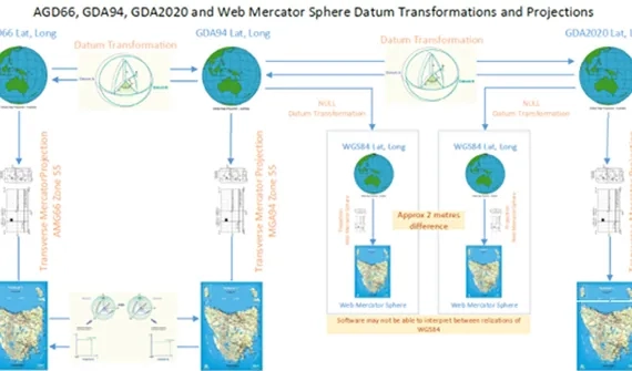
GDA2020, Australia’s new official datum, will align the country’s national coordinates with global satellite positioning systems, enabling smart devices and other positioning technology to accurately locate mapped features.
Failing to update location data to GDA2020 risks exposing discrepancies of up to 1.8 metres relative to GDA94-mapped features. That’s why you need a strategy and workplan built on a thorough analysis of your requirements.
The Esri Australia GDA2020 consultation advantage
We work with Geoscience Australia and Esri Inc to ensure inbuilt GDA2020 support across the ArcGIS product suite

Esri Australia participates in the ICSM GDA Modernisation Implementation Working Group

We collaborate with the ICSM GDA2020 technical team to communicate optimal solutions

Our consultants remain up-to-date with GDA2020 data compliance