Winner of the 2017 Esri Young Scholar Award, Alan Pearse is a research assistant and third-year bachelor student in Science (Earth Science) / Mathematics (Statistical Science) at the Queensland University of Technology (QUT). In July 2017, Esri Australia sent Alan to San Diego, California, to attend the Esri UC – the world’s largest GIS user conference.
I’ve always been interested in management and conservation, and I’m also interested in the technology aspect of it.
I brought these interests together to implement methods that had been developed and published by my supervisor, Dr Erin Peterson, in the ArcGIS toolbox IDW-Plus – Inverse Distance Weighted Percent Land Use for Streams – using the ArcPy geoscripting module in Python.
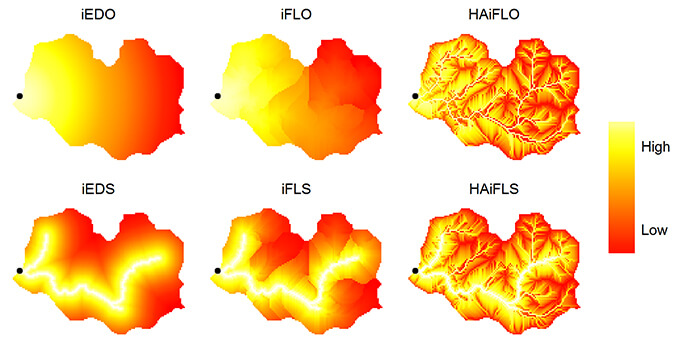
The purpose of IDW-Plus is to help Esri ArcGIS users to calculate six, spatially explicit land use metrics for watersheds:
-
inverse flow length to outlet (iFLO)
-
inverse flow length to stream (iFLS)
-
inverse Euclidean distance to outlet (iEDO)
-
inverse Euclidean distance to stream (iEDS)
-
hydrologically-active inverse flow length to outlet (HAiFLO)
-
hydrologically-active inverse flow length to stream (HAiFLS)
My objective was to bridge the gap between theory and practice in quantifying the relationship between the landscape around streams and the activities conducted on them, and how this is likely to affect their impact on stream health.
When I started working on this project, I hadn’t had much experience with ArcGIS and Esri products or Python. Nevertheless, I set out to create this tool that could better represent land use impact on stream health.
I had completed a vacation research project through QUT with the ARC Centre for Excellence for Mathematical and Statistical Frontiers.
For that project, I looked at geostatistical methods for predicting different water quality variables at large spatial scales. I specifically looked at the Great Barrier Reef and some of the open data sets that existed around that, and explored methods for predicting the value of each of those water quality variables across the reef.
After that, Dr Peterson mentioned that there was a lot of interest around having an ArcGIS toolbox that implemented her spatially explicit land use metrics, which accounted for the relationship between land use and the landscape around a stream.
In models of stream health and waterways, land use is typically measured as an unweighted areal percentage within a catchment. But that doesn’t take into account the impact of location, proximity and topography of farms, forests and urban areas on stream health.
There was no off-the-shelf solution – implementing these metrics was likely to be time-consuming and complicated because users would have to develop their own geoprocessing scripts to string together ArcGIS tools to perform potentially hundreds of thousands of operations on their data.
Doing this manually would not be an option, because that could take weeks.
So, I began thinking about how I could use products like ArcGIS and ArcMap to create a tool that could use geospatial data layers to calculate spatially explicit percentages of land use within area catchment.
Once I got started with ArcGIS and ArcMap I found that Esri had some pretty flash algorithms to delineate watersheds and catchment areas.
IDW-Plus combines computationally expensive calculations together in a process that takes hours rather than weeks.
I made the IDW-Plus toolbox available to the public along with a detailed tutorial. I know the toolbox is already making an impact, even being used by a researcher at the United States Geological Survey. I think other scientists and managers will also find this tool useful, because it allows them to simplify their workflow and be confident that the metrics have been correctly calculated.
I was ecstatic when I found out that I won the Esri Young Scholar Award.
I’m proud of the IDW-Plus toolbox, and it’s nice to have it recognised as something that other people see as valuable.
I’m looking forward to the Esri User Conference in San Diego to experience what other people are doing with GIS software and see how it’s being used, not only in environmental science and stream ecology, but also in defence, engineering, transport, health, smart cities and other areas.
Winning the Young Scholar Award means that I’ll get to do all these cool things and meet up with similarly involved people in the GIS field – and hopefully collaborate with them in the future as well.
I’m hoping to have my eyes opened to the vast range of possibilities and look forward to the opportunity to do the same for others.
If you’re an Australian university student studying geospatial sciences, you could win a trip to the next Esri UC in San Diego. Watch this space or subscribe to our newsletter for information about entries.