
A detailed digital model can help an infrastructure team see what it plans to build. A living digital twin goes further: it helps the organisation understand how that infrastructure is changing, how it is performing and what decision should come next.
That distinction matters as asset owners, delivery agencies and utilities manage ageing infrastructure, constrained capital, resilience pressures and increasingly connected networks. The challenge is rarely a shortage of models or data. It is that engineering, spatial, asset, construction and operational information often remain divided across systems and lifecycle stages. When context is lost between planning, delivery and operations, decisions become slower, risk increases and valuable information must be rebuilt.
Living digital twins offer a way to connect that information around the infrastructure itself. By combining spatial intelligence with design, asset, operational and enterprise data, they can evolve from project-based representations into enduring decision capabilities.
Infrastructure needs more than a digital representation
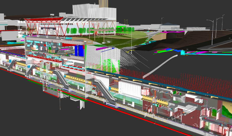
Digital models have already changed how many infrastructure projects are designed and communicated. Three-dimensional visualisation can make complexity easier to understand, improve coordination and help teams identify issues before work reaches the site. These are valuable outcomes, but a model is not automatically a digital twin, and a digital twin is not valuable simply because it looks like the physical world.
The real measure is whether it improves a decision. Can planners compare options before capital is committed? Can delivery teams understand how a design interacts with existing assets, communities and environmental constraints? Can operators see current conditions and anticipate emerging risk? Can information created during construction remain useful after handover?
Future-ready organisations connect data, people and decisions through a shared understanding of the real world. For infrastructure leaders, a digital twin can become one expression of that capability: a governed, spatially connected environment that supports decisions throughout the asset lifecycle. It can help organisations use their existing technology investments more effectively, extend trusted spatial intelligence across teams and workflows, and move faster from enterprise data and insight to operational action. Explore how spatial intelligence and Microsoft's enterprise platform can support future-ready networks.
Digital twin maturity is a journey, not a single build
Treating a digital twin as a one-off technology project creates the wrong starting point. Organisations do not move from disconnected information to a fully autonomous twin in one implementation. They progressively increase their ability to describe, understand, predict and act on change.
A descriptive twin provides a virtual representation of assets, networks or places. An informative twin connects the representation with current information, helping teams understand conditions as they change. Predictive capability uses spatial analysis, simulation, AI or machine learning to explore what may happen next. More comprehensive twins compare scenarios and support recommendations. At the most advanced level, autonomous capabilities may increasingly support or automate defined decisions within appropriate governance.
This is not a race to reach the final stage. Different assets, decisions and risk profiles will justify different levels of maturity. A project team may create significant value by connecting BIM and GIS for coordination. A utility may need current field and sensor information to improve asset maintenance. A transport operator may benefit from simulation to test demand, disruption or emergency scenarios.
The important point is that each step should solve a real problem and establish trusted foundations that can be extended. Organisations can start where they are, demonstrate measurable value and increase maturity as their needs, data and governance evolve. As the capability expands, authoritative information, clear ownership and permission-aware access become essential to ensuring the twin remains reliable and usable across the enterprise.
The destination is a living capability
A living digital twin maintains a meaningful connection between physical infrastructure and its digital representation. New information can update the organisation’s understanding of current conditions; analysis can test possible futures; decisions and field activity can feed back into the shared view. The twin evolves alongside the infrastructure rather than becoming a static record of one moment in time.
Spatial intelligence provides the connective context for this evolution. Assets, projects, services, risks and communities all exist somewhere and interact through location. ArcGIS can relate BIM and CAD models, asset registers, imagery, reality capture, sensor feeds, field observations and environmental information within that real-world context.
This supports continuity across planning, design, construction, commissioning, operations, maintenance, response and renewal. Instead of replacing systems at each stage, the spatial layer helps information move between them. Design intent can remain visible during delivery. Construction information can strengthen handover. Operational updates can improve the record used for maintenance and future planning.
The result is not one perfect model. It is a more connected infrastructure lifecycle in which teams can find, interpret and act on the information relevant to the decision in front of them.
How digital twins improve infrastructure management and decision-making
The decisions vary across the infrastructure landscape, but the need for continuity and context is shared.
- AEC and major projects. Connecting BIM, CAD, GIS and reality capture can improve design coordination, reveal interactions with the surrounding environment and preserve information from delivery into operations.
- Capital infrastructure. Spatial modelling and scenario analysis can help leaders compare options before committing capital, understand asset, community and environmental dependencies, and reduce the loss of knowledge between project and operational teams.
- Utilities. Connecting network, asset, field and operational information can support capital planning, asset lifecycle management, demand forecasting, network expansion and a clearer understanding of bushfire, flood and other environmental risks. For telecommunications networks, real-time spatial intelligence can play a similarly important role in strengthening network resilience and response. Explore how real-time spatial intelligence is transforming telecommunications networks.
Across each setting, the digital twin becomes useful when it brings together information that would otherwise be interpreted separately. That shared context helps teams see dependencies, test consequences and make decisions earlier.
From one twin to a connected system of systems
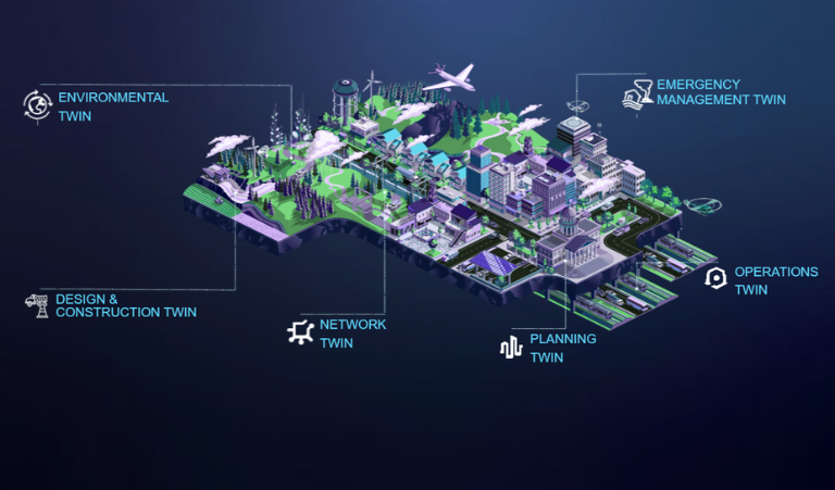
Large infrastructure organisations rarely need one monolithic digital twin. They may have many twins representing projects, facilities, networks, corridors, environments or operational domains, each governed by the teams closest to the information.
The greater opportunity is to connect these capabilities when a decision crosses their boundaries. A network expansion may depend on land use, demand, environmental risk and other infrastructure. A major project may affect transport operations, utilities and surrounding communities. An incident may require current information from asset, field, weather and emergency systems.
ArcGIS provides a shared spatial framework through which these distributed systems and models can be understood together. Information can remain governed at its source while becoming discoverable and usable in the context where it is needed. This creates a practical system-of-systems approach: not a single database or model, but a connected view of relationships across infrastructure and place.
A living digital twin in practice
Cross River Rail: Value that extends beyond construction
Cross River Rail demonstrates how this approach can support a complex infrastructure program. The project connected Autodesk BIM models with Esri GIS to create a shared 3D environment across 17 sites, bringing detailed engineering information together with geographic context.
The environment has supported design coordination, earlier identification of conflicts and decision-making before people and equipment reach the site. It has also provided a foundation for simulating station operations and emergency scenarios, helping project and operational stakeholders test procedures before opening.
Its longer-term significance lies in continuity. The digital foundation was designed not only to de-risk design and construction, but to support readiness and future operations. As information is updated and enriched, the value of the twin can grow with the railway it represents.
Connecting digital twins to the enterprise
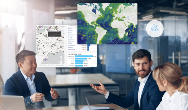
Living digital twins create greater value when they connect with the broader enterprise environment rather than operating as isolated project platforms.
Esri and Microsoft have collaborated for nearly four decades, with the partnership continuing to evolve across cloud, data, analytics, AI and productivity technologies. For infrastructure organisations, this provides a practical way to build on established technology investments while extending spatial intelligence into more systems, teams and workflows.
ArcGIS provides the spatial foundation for connecting assets, networks, BIM and CAD models, imagery, sensor feeds, field information and environmental context. It helps organisations understand not only what an asset is, but where it is, what surrounds it, and how it relates to wider infrastructure systems.
Microsoft provides complementary cloud, enterprise data, analytics, AI and productivity capabilities. Together, ArcGIS and Microsoft technologies can connect trusted spatial information with the enterprise systems and workflows infrastructure organisations already use.
This does not require organisations to replace their existing technology environment. The opportunity is to connect existing investments, extend authoritative spatial intelligence to more decision-makers and create a stronger foundation for governed AI and automation. In this way, digital twins can progress from specialist project environments into ensuring capabilities that supporting planning, delivery, operations and executive decision-making.
Start with the decision, not the digital twin
A fully realised living digital twin will not be the immediate destination for every organisation. The most effective starting point is not to ask, “How do we build a digital twin?” but to identify where a more connected understanding of infrastructure could improve a valuable decision.
Infrastructure leaders can begin by asking:
- Which decisions are being delayed by fragmented or inaccessible information?
- Where is valuable context being lost between planning, construction and operations?
- Which assets or networks would benefit from earlier risk identification or scenario modelling?
- Where could existing ArcGIS and enterprise technology investments be connected more effectively to create immediate operational value?
- What governance, data and capability foundations will be needed to extend the solution over time?
Starting with a defined business problem makes it possible to demonstrate value, strengthen the organisation's data and governance foundations, and progressively increase digital twin maturity. The objective is not to build the most advanced twin. It is to connect the right information, systems and people to improve a decision that matters.
Beyond the model
Infrastructure becomes more resilient and future-ready when organisations can maintain a connected understanding of assets, networks, risks and change across the lifecycle.
A living digital twin supports that understanding, but its value does not come from creating a more detailed representation of the physical world. It comes from connecting information, systems and people around the decisions that matter.
With ArcGIS providing the shared spatial context and Microsoft technologies supporting integration across the broader enterprise environment, organisations can build on their existing investments, start with a priority use case and develop a digital twin capability that evolves alongside the infrastructure it represents.
Confident decisions build future-ready networks.
Ready to explore what's possible? Book a 1:1 strategy session with Esri Australia and Microsoft experts to identify where spatial intelligence can accelerate your cloud, data and AI priorities.