
The Department of Natural Resources and Mines, Manufacturing and Regional and Rural Development has enhanced Queensland’s spatial data accessibility and economic resource business development prospects.
Project overview
The Queensland Department of Natural Resources and Mines, Manufacturing and Regional and Rural Development embarked on a transformative journey to revolutionise its geographic information system (GIS) infrastructure. In collaboration with Esri Australia’s Managed Services for GIS team, the initiative aimed to enhance the Department’s resource management as well as set a new standard for accessible and authoritative spatial data. The new infrastructure was cost efficient for the Department and reduced reliance on its internal IT team to maintain complex GIS applications and databases
Client in focus
The Queensland Government’s Department of Natural Resources and Mines, Manufacturing and Regional and Rural Development is responsible for the sustainable management of the State’s natural wealth spread over its vast 1.85million km2 geography. The Department provides dedicated support amongst government agencies, landholders, businesses and the broader community for land and property management, mining and exploration, and data governance and mapping.
Leading the ongoing management and accessibility of the Department’s spatial data, is the Spatial Systems team, whom over the past decade have been pushing the boundaries of spatial data guardianship.
“We regard ourselves as the authoritative source and point of truth, of spatial foundation data for Queensland.”
Paul Murtagh, Director, Spatial Systems, Department of Natural Resources and Mines, Manufacturing and Regional and Rural Development
The challenge
The key remit for the Spatial Systems team is to ensure the Department’s spatial data remains supported, secure, and accessible for internal Government users and external parties. Internal government users also faced system performance challenges due to Queensland’s vast geography and large datasets.
In addition, as the volume of datasets were increasing, the Spatial Systems team were challenged with the selection of suitable, scalable infrastructure and management approach that would handle the current data needs and their ongoing growth of digital transformation across additional data creation, in particular, LiDAR, imagery and 3D rendering for digital twin development.
A transformative partnership
In seeking a transformative partnership, the Department and its Spatial Systems team were very clear about their business requirements and vision. The fundamental criteria was to:
- Improve latency issues experienced by regional-based users
- Ensure the selected solution would enhance productivity within Government
- Continue to provide Queensland with access to an open data culture that would encourage sustainable economic and environmental development
- Provide a cost-effective solution without compromising data integrity and security
- Have a centralised, future-proof database infrastructure hosted off-premises
- Reflect a strategic “lease before you buy” approach
- Most importantly, support a comprehensive solution for the growing volumes of spatial data, (including imagery) while leveraging secure cloud storage for greater efficiencies.
The solution: Esri Australia’s Managed Services for GIS
Leveraging an existing partnership with Esri Australia provided a solution that was pivotal in the integration to the Department’s ongoing Spatial Infrastructure Renewal Project. The solution that Esri Australia proposed and provided was Managed Services for GIS.
Esri Australia’s solution met the Department’s requirements and more. In addition, the team were already successfully delivering ongoing iterations of another largescale assignment, the Spatial Infrastructure Resource (SIR).
Esri Australia provided a secure, high-performance, and low-latency cloud-native infrastructure and application management solution. The GIS infrastructure is ISO27001 certified for data handling and security. It also provides dependability and resilience that is crucial for managing and publishing spatial data effectively.
Managed Services for GIS reduced the Department’s internal management needs and allowed for seamless software management, troubleshooting, and updates. It also provided the mandatory data sovereignty required for Queensland Government Departments.
“We want an environment that can cope with the growth, we’re growing all the time at around 10% a year.”
Paul Murtagh, Director, Spatial Systems, Department of Natural Resources and Mines, Manufacturing and Regional and Rural Development
Transformative outcomes
The adoption of Managed Services for GIS has transformed the Department’s Enterprise GIS capabilities, providing them with a scalable, cost-effective solution that reduces their internal management needs at a predictable cost. It also provides a more strategic and progressive approach to data and application.
Key benefits for the Department include:
- Increased productivity among non-technical staff through a simplified and intuitive user-interface that provides access to spatial data hosting
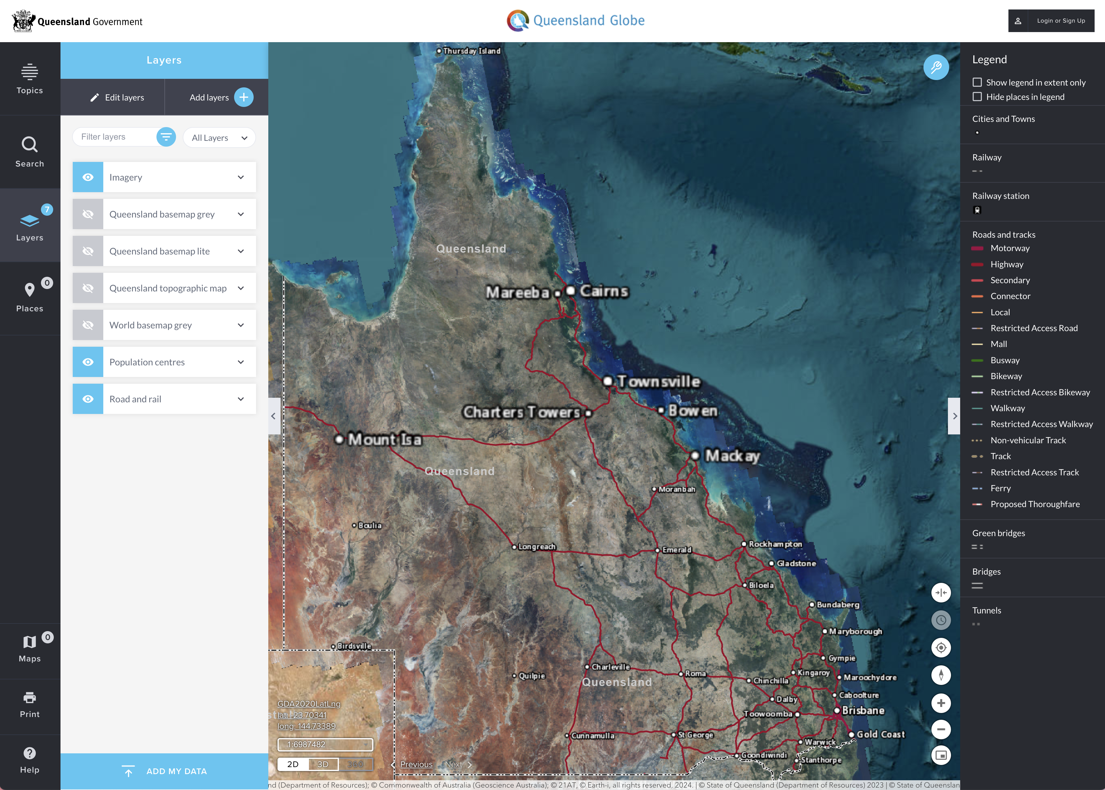
- Enhanced UI/UX of the external-facing platforms like QSpatial for external data access
- Addressed issues around data access latency, improving insights, and end-user experience
Behind the scenes
The successful seamless integration of Managed Services for GIS is evidenced by the many thousands of visitors to the Department’s online services as well as the ongoing decreased need for technical support across the Department’s 1,000+ deployed ArcGIS Online licenses. These achievements underscore the enhanced accuracy, security, reliability, and engagement with spatial data.
Working collaboratively, Esri Australia has played an important technological and advisory role that has helped set a new paradigm in the Department’s spatial data management.
What this means for your organisation
The story of Queensland Government’s Department of Natural Resources and Mines, Manufacturing and Regional and Rural Development highlights what happens when GIS is supported, not stretched.
By reducing performance issues, scaling infrastructure, and removing the burden of day-to-day system management, Managed Services for GIS created a more reliable, responsive, and efficient environment for both users and teams.
With Esri Australia managing the backend, internal teams can focus less on maintaining systems and more on delivering accessible, high-quality spatial data that drives business objectives.
Explore more about how Managed Services for GIS works
Ready to move from reactive costs to predictable performance? Connect with the Esri Australia Managed Services Team to see what's possible.