Almost everything in retail is driven by location.
Whether you are running a fast-food chain, fitness centres, or supermarkets, decisions about where things happen, stores, customers, inventory, deliveries, and incidents, shape performance every day.
Yet, in most retail organisations, location intelligence is still primarily associated with one function: site selection.
Site selection, network planning, market planning, whatever you call it, plays a critical role in business expansion. Identifying the right next location means balancing demographics, traffic, competitors, cannibalisation, store format, and available space. These decisions are complex, high stakes, and rightly get a lot of attention and rigour. Location based data and tools are often brought together to support this process, usually by dedicated teams with deep expertise.
But after working with a wide range of retail organisations, one pattern stands out. This is often where location intelligence stops being used consistently across the organisation.
The limitation is not just data or technology
Most retailers already have access to location data and spatial tools in some form. However, the limitation is both technological and organisational.
Technology is evolving rapidly, and many retailers are still behind the curve in how they adopt and integrate emerging capabilities. At the same time, organisational silos are reflected in the data itself. Disparate datasets across departments remain one of the most common and persistent challenges. AI will help address some of this fragmentation, but it is only as good as the quality, integrity, and connectedness of the underlying data.
Location intelligence usually sits within a single function, often property or network planning, while other teams are making equally important location driven decisions using different tools, different data, or no spatial insight at all. The same underlying question, where is this happening and why there, is being asked across the organisation, but answered inconsistently.
There are a few common reasons this happens:
- Familiarity: Site selection is the most established use case
- Functional silos: Teams operate in separate systems with limited shared context
- Budget constraints: Organisations often face the reality that you can afford anything, but not everything
- Awareness: Many teams do not realise their problems are geospatial
Looking beyond expansion decisions
Site selection is where many organisations begin their journey with location intelligence, but it is rarely where the value should end.
If you step back, you start to see the same types of questions being asked across the business. They are not always labelled as location problems, but they rely on the same underlying ideas of place, proximity, movement, and catchment.
Monitoring performance
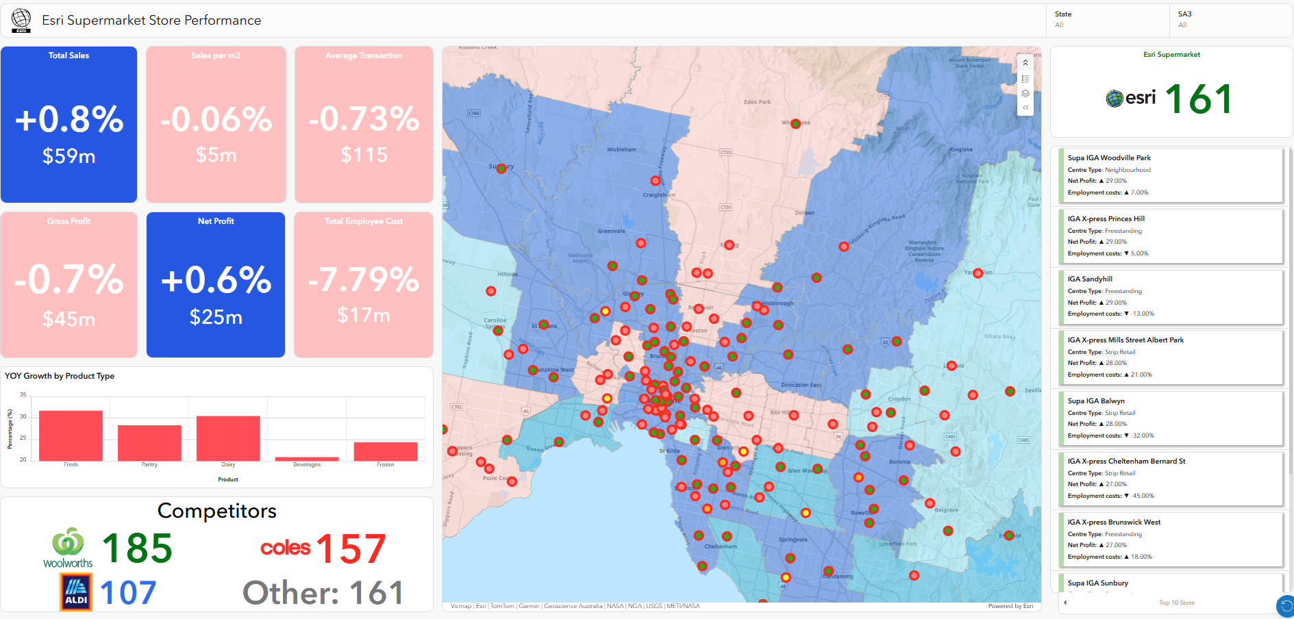
After you have taken the time to find the right site for a new store, the next question is how it is performing, and how it is impacting the rest of your network.
By visualising your store network and linking it to performance data, you start to see patterns that are difficult to pick up in spreadsheets.
- Are nearby stores being impacted by the new location?
- Are certain products selling better in specific regions?
- Why are two stores in one area performing well, while a third is not?
- If a site should be performing better, what is different about its location?
This shifts performance conversations from individual stores to a network view.
Supermarket performance dashboard example
Network optimisation
Retail networks are not static. New stores open, others close, formats change, and competitors move.
Location intelligence allows you to reassess your network continuously, not just when you are expanding. This becomes a living atlas of your organisation.
- Where are we over servicing or under servicing demand?
- Are stores cannibalising each other more than expected?
- Should stores be resized, relocated, or reformatted?
Instead of treating the network as fixed, it becomes something you actively manage over time.

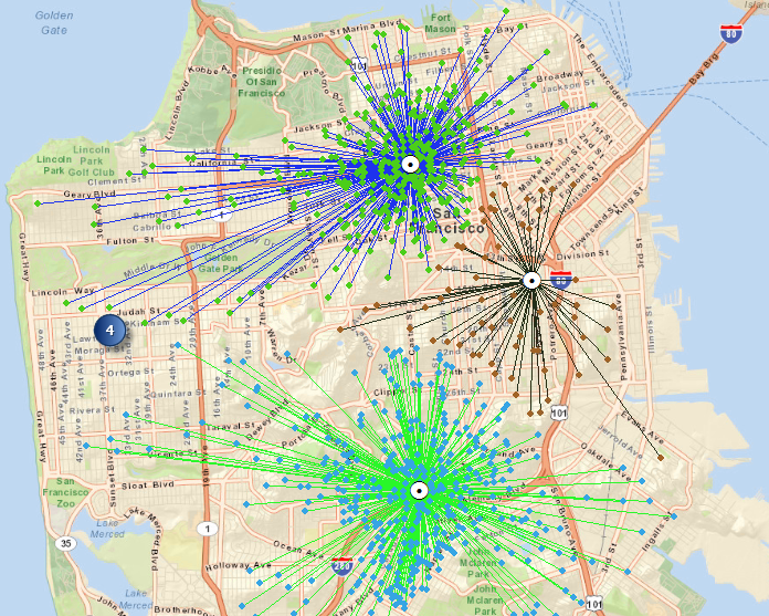
Customer analysis
You can learn a lot about your customers by putting them on a map.
Understanding where they live and how they move provides context that transactional data alone cannot. This ultimately becomes a localisation challenge, where the goal is to serve the customer in the best possible way everywhere they want to interact with the brand.
- How far are customers travelling to visit you?
- What do the areas they come from look like demographically?
- Are you attracting the customers you expected?
- Are customers coming specifically for you, or because of something nearby?
This helps align marketing, store formats, and product mix with what is actually happening on the ground, while also feeding back into site selection by refining assumptions about who each location is expected to serve.
Supply chain and logistics
Supply chain decisions are inherently spatial, but they are often treated separately from store and customer insight.
When you add new stores, dark stores, or fulfilment locations, you are not just increasing coverage. You are changing how the entire network operates.
Location intelligence helps surface those impacts:
- If we add more locations, how does that affect delivery times across regions?
- How does it impact distribution centre capacity and throughput?
- Are we creating efficiencies, or simply shifting bottlenecks elsewhere?
- Where are delivery times or costs higher than they should be today, and why?
Without a spatial view, these tradeoffs are difficult to see.
Case study: The ethics of supply chain transparency
Ecommerce
Even in ecommerce, location still matters, and increasingly so as locations become multi-functional, supporting discovery, transaction, fulfilment and information or service.
Behind every online order is a decision about where it is fulfilled and how it reaches the customer. These decisions are often made quickly, but they have wider implications.
- Is the product coming from a store or a warehouse?
- If stores are used, which locations make the most sense?
- Should deliveries be handled through traditional post, or through aggregators like Uber and other last mile providers?
- How do these options impact cost, speed, and operational complexity?
- How should delivery routing evolve as demand changes?
These are not isolated decisions. They connect directly back to supply chain design and store operations.
Sustainability
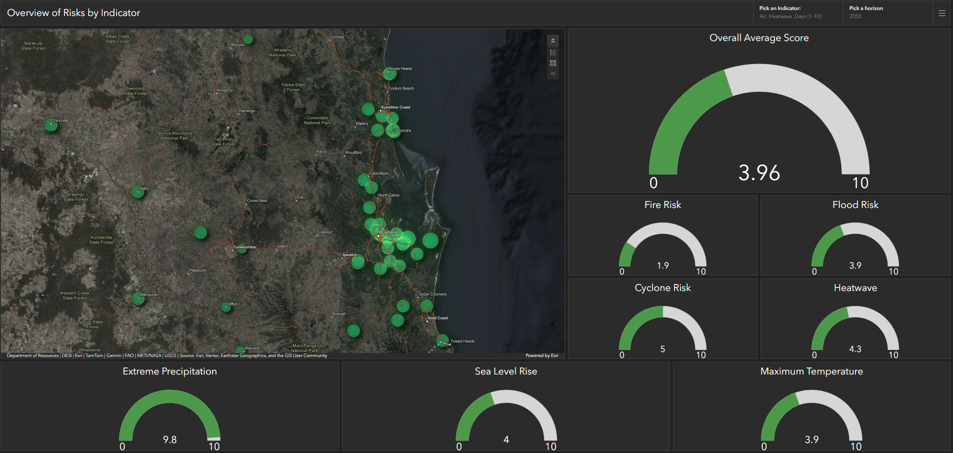
Sustainability is becoming a bigger focus, and location plays a major role. In Australia, climate considerations are increasingly important, both because of real world impacts and evolving regulations such as ASRS. Retailers are increasingly expected to understand how climate risk affects their operations, and much of that risk is spatial.
Transport distances, store operations, and network design all contribute, but so does where your assets are located.
Location intelligence can support:
- Reducing unnecessary travel in supply chains
- Identifying opportunities for more efficient routing
- Understanding the environmental impact of network decisions
- Identifying stores or distribution centres at risk of flood, bushfire, or extreme weather
Climate risk also links directly back to network planning:
- What happens if a key distribution centre is disrupted?
- Are multiple parts of the network exposed to the same risk?
- How resilient is the network to regional disruptions?
This moves sustainability beyond reporting and into something you can actively manage.
Climate risk indicator example
Risk and safety
Retailers deal with location-based risks every day, and for many organisations, this has become one of the most pressing operational challenges.
These are often managed reactively, but when viewed spatially, patterns start to emerge.
- Where are incident hotspots across the network?
- How does risk vary by region, store type, or time of day?
- What external factors are influencing that risk?
- Where should investment in mitigation be prioritised?
- Which locations are exposed to environmental risks such as flood or bushfire?
Risk is also not isolated to one store.
- Are clusters of locations exposed to the same risks?
- Do certain areas require additional support or contingency planning?
Bringing this into a spatial view helps shift from reacting to problems towards anticipating them.

Asset management and inspections
Retail networks are made up of thousands of physical assets, from stores and equipment to signage and infrastructure, all requiring ongoing maintenance and compliance.
These assets are inherently tied to location but are often managed without spatial context. Bringing in concepts such as digital twin can help provide a richer and more connected view of these assets.
Bringing asset and inspection data into a location aware view helps surface patterns that are difficult to see otherwise:
- Where are assets nearing end of life, and are they clustered in certain regions?
- Are maintenance issues concentrated in specific locations or store types?
- How efficiently are field teams travelling between inspection sites?
- Are inspections being completed consistently across the network?
- Which assets are exposed to environmental risks such as flood, heat, or corrosion?
When inspection and maintenance data is visualised geographically, organisations can move from reacting to issues towards proactively managing them. Instead of responding to failures as they occur, teams can prioritise work, allocate resources more effectively, and ensure more consistent coverage across the network. When combined with performance, risk, and network data, this also helps organisations understand how asset condition impacts store performance, customer experience, and operational efficiency.
From tools to capability
Across all of these examples, the common thread is understanding where things happen and why that matters.
But in most organisations, each team approaches this independently, using different systems and different data.
The opportunity is not more tools. It is about treating location intelligence as shared capability.
A key part of this is connecting the data that already exists across the business.
Property, operations, supply chain, marketing, and risk teams all hold different pieces of the picture, including store data, customer data, logistics data, and incident data. These datasets all have a spatial component, but they are rarely brought together.
Without that integration, teams are solving different parts of the same problem based on partial views.
This shift might include:
- A shared spatial data foundation that integrates data from multiple systems
- Bringing departmental datasets into one central location aware environment
- Consistent definitions of trade areas and catchments
- Shared dashboards that combine performance, customer, supply chain, and risk data
- Cross functional workflows built around location-based insight
When this comes together, location stops being a specialist tool and becomes part of how the business operates.
The shift
Most retailers are already using location across the business.
Property teams use it for site selection. Operations track performance. Supply chain plans around it. Marketing uses it for targeting. Risk teams monitor it.
The issue is not usage. It is that these teams are not connected.
They are all solving different parts of the same problem, but without a shared view of it across the organisation. Decisions that should complement each other end up being disconnected, and sometimes even work against each other.
At its core, every team is still asking the same question: where is this happening and why there?
The difference is whether the organisation answers it consistently, with shared data, a common language, and the ability to look at that data holistically.
An organisational approach
By connecting data, systems, and teams through a shared view of location, retailers can:
- Align decisions across functions instead of optimising in isolation
- Understand trade-offs across the entire network
- Respond more effectively to change
- Build a more resilient and efficient operation
This is not about doing something new. It is about connecting what already exists and using location as a common language across the business.
Book a demo today and explore how ArcGIS can break down data silos to transform your retail operations.