Geoscience Australia has released a public Story Map about the data behind the search for MH370.
On 8 March 2014, Malaysia Airlines flight MH370 disappeared from air traffic control radar during a flight from Kuala Lumpur, Malaysia, to Beijing, China, with 239 passengers and crew on board.
On 31 March 2014, the Malaysian and Australian governments agreed that Australia would take the lead in the search operation in the southern Indian Ocean.
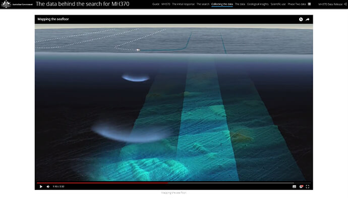
The search operations involved multiple organisations, with Geoscience Australia collecting, processing and analysing large volumes of marine data from the remote area. The data obtained during the first phase of seafloor mapping is now available to the public, and is seen as providing valuable insight into other scientific research.
© Commonwealth of Australia (Geoscience Australia) 2017
Geoscience Australia is Australia’s public-sector geoscience organisation and the nation’s trusted advisor on the geology and geography of Australia. Geoscience Australia chose to use Esri Story Maps to leverage the combined features of ArcGIS web maps and multimedia content to tell the story about the data behind the search for MH370.
The MH370 Story Map tells the story of the search, the collection of data and how the public can now access the available data.
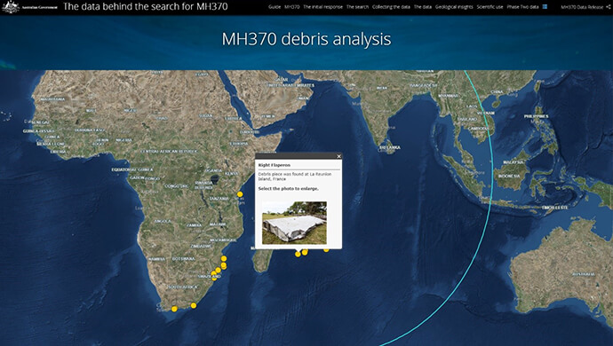
Interactive maps describe the initial surface and air search and the subsequent underwater search for the flight recorders. Maps and videos show how the data was collected, and what the seafloor bathymetry looks like. With the Story Map, viewers can look at locations of debris and view drift modelling conducted by CSIRO.
© Commonwealth of Australia (Geoscience Australia) 2017
The search is one of the largest marine surveys ever conducted. 278,000 square kilometres of shipboard bathymetry data was collected within the search area, with another 432,000 square kilometres of data collected as the vessels transited between Perth, Fremantle and the search area. In addition to the scale of the search area, the remote location makes this bathymetric survey unique.
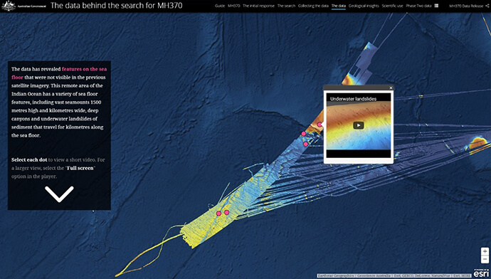
Along with identifying large geological formations and several shipwrecks, the search uncovered a number of smaller items on the sea floor, including whale bones, steel cables and oil drums.
The Story Map shares the story of the search for MH370 in an interactive, visual format, showing the most interesting geomorphic features in a web browser, with fly through visualisations, images and annotations available at the click of a button.
The maps show how the data revealed seafloor features such as volcanoes and underwater landslides that hadn’t been previously visible in lower-resolution satellite-derived data.
Phase One data is now ready to download through links provided in the Story Map. While the data was collected for the sole purpose of locating the missing aircraft, it will continue to be valuable to scientists across diverse disciplines.
© Commonwealth of Australia (Geoscience Australia) 2017
Using the data sources shown in the Story Map, scientists will be able to analyse underwater features to conduct habitat and oceanographic modelling. Any GIS user will be able to use this data in their GIS to gain insights and conduct their own research. Desktop GIS like ArcGIS Pro will allow users to map, visualise, animate and analyse the data in 3D.
The MH370 Story Map was used to successfully communicate this highly technical story to members of the public with little or no previous GIS experience. Story Maps on the ArcGIS platform are able to scale up to meet the needs of high volumes of users and can be embedded in your own webpages.
Story Maps let you combine authoritative maps with narrative text, images, and multimedia content, making it easy to harness the power of maps and geography to tell your story. Story Maps are built from easy-to-use templates that require no coding experience.
To start using Story Maps to tell your story, get in touch with Esri Australia on 1800 870 750 or send us an email.