The 2026-27 Federal Budget outlines significant investment across housing, infrastructure, healthcare, energy, defence, and regional development.
But beyond the funding announcements themselves, the Budget also reflects something broader: how complex it has become to deliver national priorities across interconnected systems, infrastructure networks, and communities.
Because while investment may be allocated through policy and funding measures, delivery ultimately happens in specific locations, across the communities, infrastructure networks and service environments those decisions are designed to support.
Where housing growth intersects with transport capacity. Where healthcare accessibility is shaped by distance and population change. Where infrastructure expansion influences freight movement, utilities, environmental pressures, and community services simultaneously.
This is what makes the Federal Budget inherently spatial.
Increasingly, the challenge is not simply identifying where investment is required, but understanding how infrastructure, services, assets, and communities interact across rapidly evolving operational environments.
A spatial approach brings infrastructure, demographic, environmental, operational and service data together – giving delivery teams a connected view of how priorities play out on the ground.
Housing supply is becoming a coordination challenge
Housing investment is one of the defining priorities within the 2026-27 Federal Budget, with funding focused on increasing housing supply and enabling infrastructure to support growing communities.
But the Budget also reinforces that housing delivery can no longer be viewed as a standalone construction challenge.
New housing growth places simultaneous pressure on transport networks, utilities, healthcare access, education services, and community infrastructure – often across already constrained metropolitan and regional environments.
As housing targets accelerate, the real challenge shifts to coordination – ensuring growth, infrastructure capacity, accessibility, and service demand are planned together.
This is especially evident in high-growth corridors where housing, infrastructure, population growth, and community services are deeply interconnected. In outer-metropolitan growth areas, for example, new housing cannot be considered in isolation from transport capacity, school availability, and access to primary and urgent care.
By bringing demographic, transport, infrastructure, environmental, and service data into a shared view, planning teams can see these interdependencies more clearly, including where pressure is building and coordination may be falling short.
That interdependence extends to the infrastructure networks that support housing, networks that are becoming more complex as communities grow and service expectations increase.
Infrastructure investment is increasingly interconnected
The same interdependence extends to the infrastructure networks that support housing, economic activity, and community growth.
The Budget also includes significant investment across transport, freight, utilities, and regional infrastructure initiatives.
But infrastructure delivery is becoming increasingly interconnected across systems, jurisdictions, and operational environments.
Transport corridors influence housing growth. Freight networks influence supply chains and industrial development. Utilities infrastructure intersects with energy resilience, environmental constraints, and long-term population demand.
This creates more complex planning and operational environments for organisations responsible for infrastructure delivery and management.
As infrastructure systems become more connected, there is growing focus on understanding how assets, services, demand, and operational risk interact across networks and regions.
Geospatial technology supports this by helping organisations visualise infrastructure systems spatially, analyse accessibility and coverage, and monitor operations to ensure continuous performance. Spatial context enhances our understanding of how infrastructure networks interact across communities and environments.
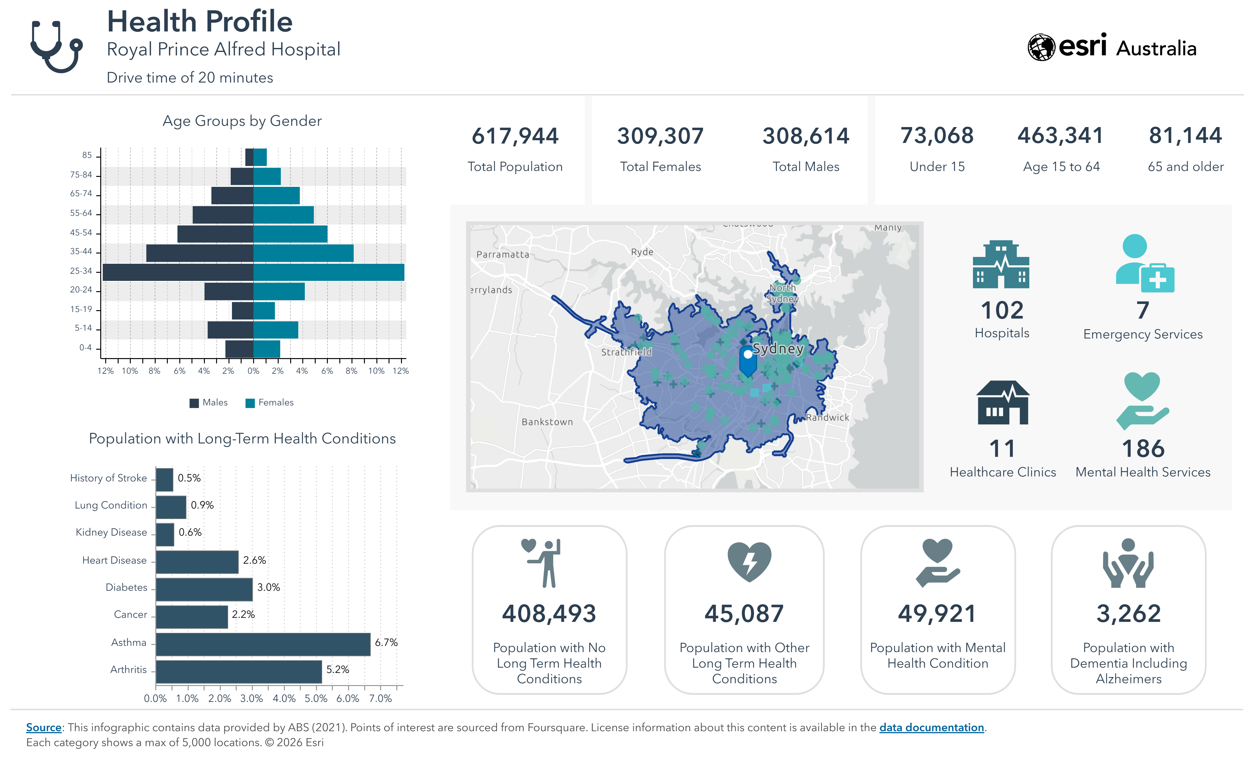
These infrastructure decisions ultimately shape how people access the services they rely on every day. Nowhere is that connection more visible than in healthcare, where service availability, population demand, transport access, and community needs all intersect.
Healthcare accessibility is shaped by place
The connection between infrastructure, growth, and community outcomes is particularly apparent in healthcare.
The Budget also includes major investment across hospitals, urgent care clinics, aged care, and broader health services. But healthcare accessibility is shaped by far more than service availability alone.
Travel times, regional growth, demographic change, infrastructure access, and service coverage all influence how communities experience healthcare access across metropolitan, regional, and remote Australia. These factors directly shape health outcomes, particularly in regional and remote communities where patients may travel hours to reach a GP, urgent care clinic, or emergency department.
The Budget’s continued focus on accessibility and service expansion reflects the growing importance of understanding where accessibility gaps, service pressures, and population demand intersect geographically.
This is particularly relevant as healthcare systems respond to population growth, ageing communities, and increasing demand across both urban and regional areas.
A shared spatial view helps health planners and service providers bring these factors together, supporting clearer analysis of where services are reaching communities, where pressure is building, and where gaps remain.
Taken together, these priorities reveal a broader pattern. The Budget is not funding isolated programs - it's funding systems that are deeply connected to one another, and whose impact depends on how well they are understood and coordinated across place.
The Budget reflects increasingly interconnected national priorities
One of the clearest themes emerging from the 2026-27 Federal Budget is the interconnected nature of Australia’s national priorities.
Housing is connected to infrastructure. Infrastructure is connected to productivity. Productivity is connected to resilience, healthcare access, energy systems, and community outcomes.
As these systems become more connected, the operational complexity of delivering national priorities also increases but so does community resilience. Decisions in one area can create flow-on effects across regions, networks, services, and communities.
That is why viewing these priorities through a spatial lens is so important. It provides clearer context on how investment, infrastructure, population growth, and service delivery come together across place — and where coordination is needed to support more effective delivery.
This is driving greater focus on how organisations understand the relationships between infrastructure, services, assets, communities, and operational environments.
That is why the Federal Budget is inherently spatial.
And as organisations across government, utilities, infrastructure, and industry respond to evolving national priorities, geospatial technology is playing an increasingly important role in helping them understand the environments in which delivery occurs.
Because ultimately, national priorities are not delivered through policy alone. They are delivered on the ground - across real infrastructure, real communities, and real places. Geospatial capability helps organisations see those connections more clearly, supporting more coordinated decisions across the environments where that work happens.
For more information about the Australian Federal Budget, visit: Budget.gov.au | Budget 2026–27