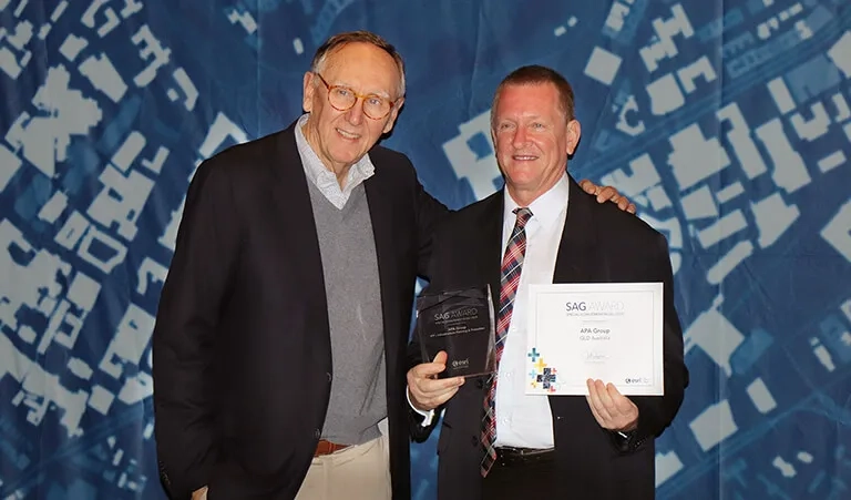
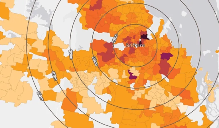
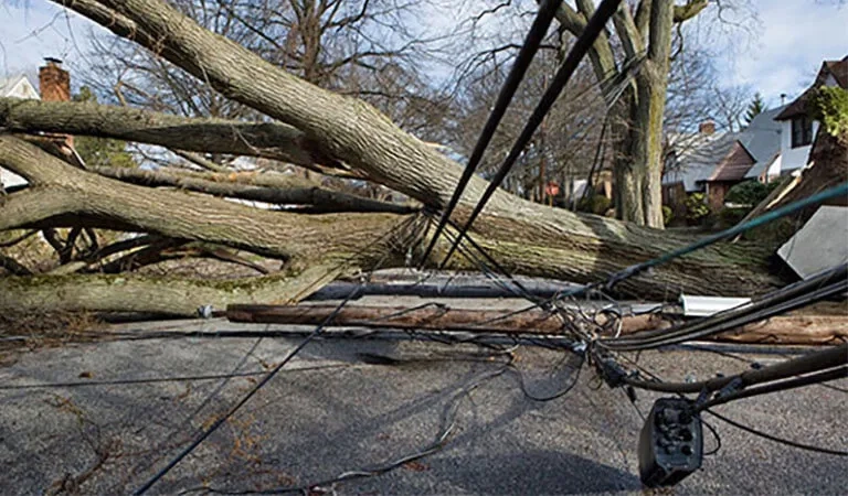
You are here News & Events News News Search news Search by year All2026202520242023202220212020201920182017201620152014201320122011 Tags - Any -#Cross River Rail3DAbout GISABSAECAFAC22AgileAgribusinessAgricultureAnalyticsApplication developmentAppsAppStudioArcGISArcGIS 10.5ArcGIS 10.6ArcGIS dashboardsArcGIS EnterpriseArcGIS Enterprise upgradeArcGIS HubArcGIS IndoorsArcGIS OnlineArcGIS ProArtificial intelligenceAsset managementAugmented realityAustralian Bureau of StatisticsAustralian bushfireAustralian GIS Hall of FameAutodeskBankingBIBig DataBig Data AnalyticsBIMBorder PatrolBrian BoulmayBusinessBusiness IntelligenceCadastreCalifornia CoastlineCitizen engagementClimate ChangeCloudCloud computingCloud GIScollaborationCollectorCommercialCommercial propertyCommunityConstructionContentCoronavirusCouncilCOVID-19COVID-19 vaccineCrisisCrowdsourcingDataData analyticsData transformationData visualisationData-driven decisionsDBYDDeep learningDefence and intelligenceDekhoDepartment of DefenceDesignDial Before you DigDigital transformationDigital twinDisability Servicesdisaster management Disaster resilienceDisruptive appsDNRMEdrone mapping DronesEarth observationsEducationeLearningElectionElectorateElectricElectricityEmergency managementEmergency responseEmergency servicesEnergyEnergy QueenslandEnergy, oil, gas and renewablesEngineeringEnterprise advantage programEnterprise GISENVIEnvironmental managementEnvironmental scienceEsriEsri AustraliaEsri Petroleum ConferenceEsri UCEsri Utility Network ModelEsri Young Scholar AwardEsri Young Scholars AwardEventsFederal governmentField data collectionFinancial institutionsFinancial servicesflood Food securityForestryForresterGasGDA2020GDA94Geo hubGeoAIGeoAnalyticsGeographic datumGeographic Information SystemsGeoscience AustraliaGeospatial AnalyticsGeospatial excellence awardGISGIS DayGIS for schoolsGIS Hall of Fame AwardsGIS managerGIS server softwareGIS ServicesGIS technologyGIS TrainingGIS web servicesGovernmentHealthHealth and human servicesHigher educationHomeland SecurityIcon WaterIDLImageryImpact AwardsIndoor navigationInfrastructureInnovationInsights for ArcGISInsuranceInsurance and BankingInteractive mapsInternet of ThingsInternshipInteroperabilityIoTJack DangermondJavaScriptLand AdministrationLand managementLaura DangermondLaw enforcementLive dataLive sensorsLocal governmentLocate22Location intelligenceLocation-based analyticsLogisticsMachine learningManaged servicesMapping and chartingMapsMarine scienceMaritimeMediaMicrosoft AzureMiningMining explorationMobileMobile applicationsMobile GISNational developmentNational SecurityNot for profitOH&SOilOpen dataOpen platformOperational awarenessOz MineralsOzriPartnershipPetroleumPlanningPlantationPortsPredictive analysisProductsPublic safetyPublic sectorPublic worksQueensland GlobeRaster dataReal-time analyticsRecoveryRemote sensingResilient communitiesResourcesRetailROISaaSSafe communitiesSAG AwardsSAPSAR ImagerySARscapeSatellite imagerySensorsServices overviewSituational awarenessSmart citiesSmart communitiessmart governmentSmart transportSmarterWXSolar eclipseSpatial data infrastructure solutionsSpeculative designStartupsState governmentStateStatStory mapsSupply chain managementSurvey123SustainabilitySustainable developmenttechnical debtTelcoTelecommunicationsTrainingTransformationTransportTransport analyticsTransport and InfrastructureTransportationTrimbleUIUnearthed ChallengeUnited NationsUniversitiesUnmanned Aerial VehiclesUrban analyticsUrban planningUser experienceUser interfaceUser researchUtilitiesUtility networkUXUXGVaccine distributionvegetation managementVirtual realityWaterWaterfallWeb GISWGS84White paperWHO ACT Government awarded global tech achievement The ACT Government has been recognised globally for their innovative use of GIS technology to transform their building and reporting standards. Learn more ANU student recognised on world-stage for perinatal healthcare research The Esri Young Scholar Award for 2020 has been awarded to Cynthia Parayiwa, an ANU student who used GIS technology to determine the impacts that location has on women's prenatal health. Learn more Esri named a leader in location intelligence platforms report The Forrester Wave highlights the company's long-term commitment to the development of a shared global geospatial infrastructure. Learn more News Esri partners with WHO as part of COVID-19 response Integrated geospatial data and analytics is important to a dynamic response to the rapidly changing situation related to COVID-19. Learn more News Landmark partnership to revolutionise public works Dial Before You Dig Vic/Tas has taken a new approach to construction projects by introducing world-leading automation software. Learn more News Real-time map tracks Coronavirus outbreak John Hopkins University has used cutting-edge technology to provide the public with a real-time, dynamic map of the global Coronavirus outbreak. Learn more News NASA releases 3D view of Australia's bushfire smoke Take a look at the interactive map providing a 3D view of Australia's extreme smoke plumes from ravaging bushfires that continue to devastate. Learn more News Another year, another 365 days of GIS! This GIS Day we took a look at the groups who have harnessed this technology to tackle some of today's biggest global challenges. Learn more Filling the gap in disability service delivery: Building a spatial bridge Learn more ACT student recognised on world-stage for crowdsourced tech innovation Learn more ACT ESA take global award for world-first tool mitigating fire risk ACT ESA, take global accolade for bushfire preparedness tool and influence emergency management industry beyond Australia's borders Learn more Aussie utility scores global innovation award Learn more Modernising GIS for a fully connected network Learn more ABS maps provide insights into Aussie electorates Learn more Interactive maps tell the story behind property price slumps Learn more Australia's most high-tech response to natural disaster Learn more Cold case king advises Australian law enforcers Learn more
ACT Government awarded global tech achievement The ACT Government has been recognised globally for their innovative use of GIS technology to transform their building and reporting standards. Learn more
ANU student recognised on world-stage for perinatal healthcare research The Esri Young Scholar Award for 2020 has been awarded to Cynthia Parayiwa, an ANU student who used GIS technology to determine the impacts that location has on women's prenatal health. Learn more
Esri named a leader in location intelligence platforms report The Forrester Wave highlights the company's long-term commitment to the development of a shared global geospatial infrastructure. Learn more
News Esri partners with WHO as part of COVID-19 response Integrated geospatial data and analytics is important to a dynamic response to the rapidly changing situation related to COVID-19. Learn more
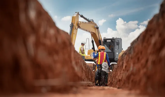
News Landmark partnership to revolutionise public works Dial Before You Dig Vic/Tas has taken a new approach to construction projects by introducing world-leading automation software. Learn more
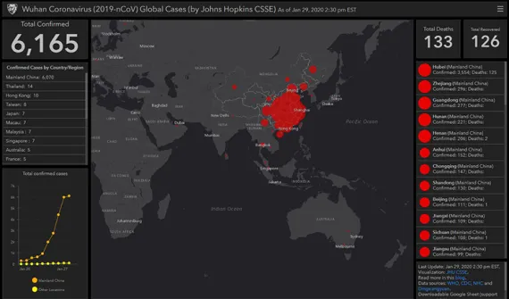
News Real-time map tracks Coronavirus outbreak John Hopkins University has used cutting-edge technology to provide the public with a real-time, dynamic map of the global Coronavirus outbreak. Learn more
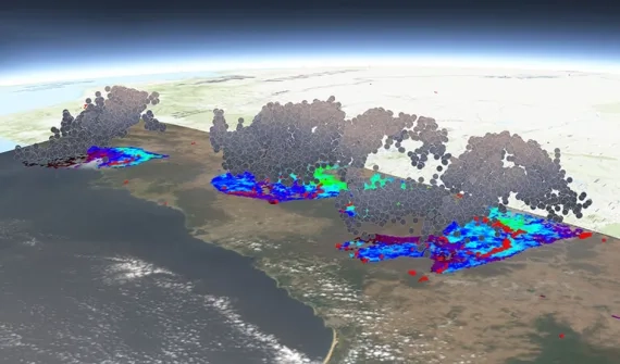
News NASA releases 3D view of Australia's bushfire smoke Take a look at the interactive map providing a 3D view of Australia's extreme smoke plumes from ravaging bushfires that continue to devastate. Learn more
News Another year, another 365 days of GIS! This GIS Day we took a look at the groups who have harnessed this technology to tackle some of today's biggest global challenges. Learn more
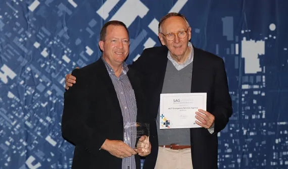
ACT ESA take global award for world-first tool mitigating fire risk ACT ESA, take global accolade for bushfire preparedness tool and influence emergency management industry beyond Australia's borders Learn more