GIS technology is now bringing even more detailed visualisation to maps and data through 3D, Virtual Reality (VR) and Augmented Reality (AR). In this post I’m going to show you how you can get your Enterprise GIS data into AR.
Augmented Reality is the view of the real world supplemented with computer-generated inputs such as maps, GIS data, text, images and videos. Augmented Reality uses GPS data to take your location and the location of GIS features to superimpose your data on a video feed from your mobile device.
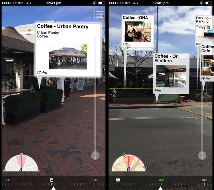
Recently, I’ve been having a play with the Esri app AuGeo. This app allows me to easily bring data from my existing ArcGIS Online point feature layers into an Augmented Reality mobile app. You can have a go too because the app is available to ArcGIS users for free in the iTunes and Google Play stores. In the app, I can access any of my own point layers and AR-ready point layers that have been shared publicly or across my organisation.
Using AuGeo I’m able to bring in my ArcGIS Online point data and attributes into AR. I can add points for local coffee shops, with names, information and photos.
There are many applications that really benefit from the added situational awareness that comes from Augmented Reality GIS.
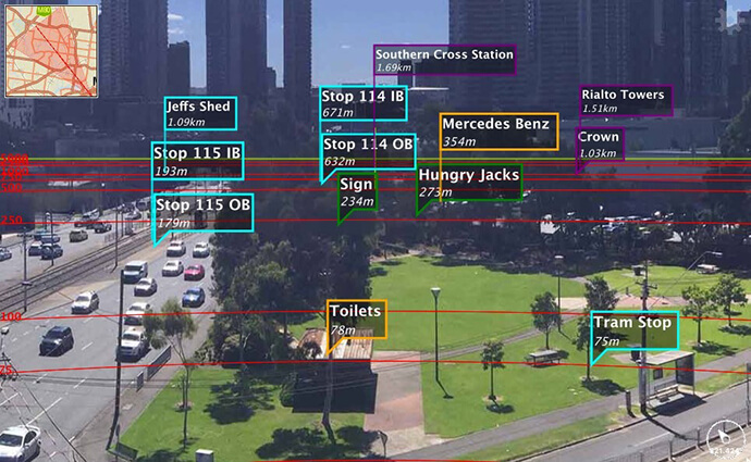
AR GIS helps you orient yourself and identify geographic features. You can find these by turning around and looking at photos of geographic locations that have been created as point features. By adding photos to an interactive map you can see – for example – if you walked down the right street, or if you are about to chop down the right tree.
Esri’s AR technologies connect to your GIS platform. This means that you connect your AR apps into Enterprise-wide workflows. You can collect data from field teams or a public crowdsourcing app, process data in the office and connect to this same data with your AR app. This saves you time and avoids repetition.
The source code of AuGeo is available with AppStudio for ArcGIS 2.0. If you are a developer, you can embed AR functionality into your own applications, or even brand AuGeo for your own purposes. If like me, you are not a developer, remember that the graphical user interface in AppStudio makes it really easy to make AR apps.
If you want to make your own AR app, our Professional Services team are here to help. We can help you create your own custom AR apps that use sensors to improve the accuracy of your GIS features.
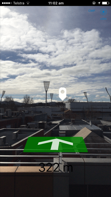
Esri used AppStudio to take the AuGeo AR view and embed it within another Esri Labs app called Trek2There, a smart AR compass that points towards your destination. Check out the screenshot I took going to Manuka Oval from our Canberra office.
There will be plenty more Esri AR apps to come. Esri are already working on incorporating the AuGeo AR view into Map Tour Story Maps.
For more information on how you can get your Enterprise GIS data into AR apps, call 1800 870 750 or send us an email.