
Common workflows
Whether you're a beginner or an experienced user, our comprehensive guide covers common workflows in ArcGIS Pro, from creating maps and analysing data to performing advanced spatial analysis and geostatistics.
Explore the resource below to unlock the full potential of your GIS workflows with ArcGIS Pro.
- Navigate maps
Map navigation tools that are found on the Tools toolbar in ArcMap, ArcGlobe, and ArcScene are on the Map ribbon tab in ArcGIS Pro.
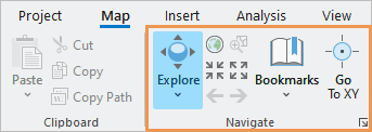
In ArcMap, tools such as Pan, Zoom, Identify, and HTML Pop-up are used for navigation and data exploration. In ArcGIS Pro, the functionality of these tools is combined in the Explore tool. With the Explore tool, you can use mouse buttons to navigate 2D maps and 3D scenes.
- Identify features
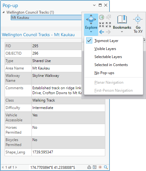
Unlike ArcMap, ArcGIS Pro doesn't have an Identify tool. To identify a feature on a map, ensure the Explore tool is active, and click the feature to open its pop-up. Click the drop-down arrow on the Explore tool to identify features in different layers.
- Manage data
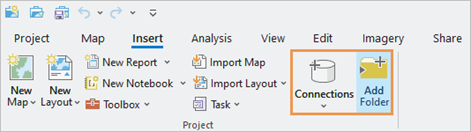
In ArcCatalog, or in the Catalog window in ArcMap, you add connections to folders, databases, and servers. In ArcGIS Pro, you can add connections in the Catalog pane, in catalogue views, or from the Insert tab on the ribbon.
Connections in ArcGIS Pro are specific to the project to which they are added. You can use project favourites to add frequently used connections to new projects.
Common data management tasks such as copying, moving, and deleting items are performed in the Catalog pane or a catalogue view. The Catalog pane is comparable to the Catalog window in ArcMap; a catalogue view is similar to ArcCatalog, although it's not a stand-alone application.
- Edit data
In ArcMap, you start an edit session to begin editing, and you stop the edit session when you're done. In ArcGIS Pro, editing is enabled by default and there is no need to start an edit session. Editing tools are available on the Edit tab of the ribbon when a map view is active. The default editing behaviour also allows you to edit a table's attribute values and to add or delete table rows. When you're finished, you save or discard edits on the Edit tab.
For an experience similar to ArcMap, you can configure ArcGIS Pro to start and stop editing.
- View and edit metadata
Metadata in ArcGIS format can be viewed and edited in ArcGIS Pro. You don't need to upgrade or import metadata that is in ArcGIS format. ArcGIS Pro supports the same metadata styles as ArcCatalog and ArcMap. In ArcGIS Pro, the default metadata style is Item Description.
Metadata for datasets and other items such as maps, layouts, and tools is displayed in the details panel of a catalogue view. In ArcCatalog, you view metadata on the Description tab. ArcGIS Pro provides a similar experience on the Metadata tab.