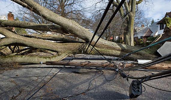
You are here News & Events News News Search news Search by year All20242023202220212020201920182017201620152014201320122011 Tags - Any -#Cross River Rail3DAbout GISABSAECAFAC22AgileAgribusinessAgricultureAnalyticsApplication developmentAppsAppStudioArcGISArcGIS 10.5ArcGIS 10.6ArcGIS dashboardsArcGIS EnterpriseArcGIS HubArcGIS IndoorsArcGIS OnlineArcGIS ProArtificial intelligenceAsset managementAugmented realityAustralian Bureau of StatisticsAustralian bushfireAustralian GIS Hall of FameAutodeskBankingBIBig DataBig Data AnalyticsBIMBorder PatrolBrian BoulmayBusinessBusiness IntelligenceCadastreCalifornia CoastlineCitizen engagementClimate ChangeCloudCloud computingCloud GIScollaborationCollectorCommercialCommercial propertyCommunityConstructionContentCoronavirusCouncilCOVID-19COVID-19 vaccineCrisisCrowdsourcingDataData analyticsData transformationData visualisationData-driven decisionsDBYDDeep learningDefence and intelligenceDekhoDepartment of DefenceDesignDial Before you DigDigital transformationDigital twinDisability Servicesdisaster management Disaster resilienceDisruptive appsDNRMEdrone mapping DronesEarth observationsEducationeLearningElectionElectorateElectricElectricityEmergency managementEmergency responseEmergency servicesEnergyEnergy QueenslandEnergy, oil, gas and renewablesEngineeringEnterprise advantage programEnterprise GISENVIEnvironmental managementEnvironmental scienceEsriEsri AustraliaEsri Petroleum ConferenceEsri UCEsri Utility Network ModelEsri Young Scholar AwardEsri Young Scholars AwardEventsFederal governmentField data collectionFinancial institutionsFinancial servicesflood Food securityForestryForresterGasGDA2020GDA94Geo hubGeoAIGeoAnalyticsGeographic datumGeographic Information SystemsGeoscience AustraliaGeospatial AnalyticsGeospatial excellence awardGISGIS DayGIS for schoolsGIS Hall of Fame AwardsGIS managerGIS server softwareGIS ServicesGIS technologyGIS TrainingGIS web servicesGovernmentHealthHealth and human servicesHigher educationHomeland SecurityIcon WaterIDLImageryImpact AwardsIndoor navigationInfrastructureInnovationInsights for ArcGISInsuranceInsurance and BankingInteractive mapsInternet of ThingsInternshipInteroperabilityIoTJack DangermondJavaScriptLand AdministrationLand managementLaura DangermondLaw enforcementLive dataLive sensorsLocal governmentLocate22Location intelligenceLocation-based analyticsLogisticsMachine learningManaged servicesMapping and chartingMapsMarine scienceMaritimeMediaMicrosoft AzureMiningMining explorationMobileMobile applicationsMobile GISNational developmentNational SecurityNot for profitOH&SOilOpen dataOpen platformOperational awarenessOz MineralsOzriPartnershipPetroleumPlanningPlantationPortsPredictive analysisProductsPublic safetyPublic sectorPublic worksQueensland GlobeRaster dataReal-time analyticsRecoveryRemote sensingResilient communitiesResourcesRetailROISaaSSafe communitiesSAG AwardsSAPSAR ImagerySARscapeSatellite imagerySensorsServices overviewSituational awarenessSmart citiesSmart communitiessmart governmentSmart transportSmarterWXSolar eclipseSpatial data infrastructure solutionsSpeculative designStartupsState governmentStateStatStory mapsSupply chain managementSurvey123SustainabilitySustainable developmenttechnical debtTelcoTelecommunicationsTrainingTransformationTransportTransport analyticsTransport and InfrastructureTransportationTrimbleUIUnearthed ChallengeUnited NationsUniversitiesUnmanned Aerial VehiclesUrban analyticsUrban planningUser experienceUser interfaceUser researchUtilitiesUtility networkUXUXGVaccine distributionvegetation managementVirtual realityWaterWaterfallWeb GISWhite paperWHO News Australia's most high-tech response to natural disaster Ergon Energy used a world-first web-GIS incident management system to coordinate recovery efforts during Tropical Cyclone Debbie. Learn more Learn more Esri joins World Ocean Council Esri has joined the ocean business alliance World Ocean Council (WOC) and will support its international initiatives for sustainable development and conservation of the ocean. Esri chief scientist Dawn Wright will share her geospatial expertise with WOC's Learn more Joint army, navy, air force approach to deliver single point of truth Learn more Spatial giants form landmark industry partnership Learn more March of the little penguins to a more certain future Learn more Sky's the limit for Perth Airport GIS Learn more IT industry giants showcase latest advances at Ozri Learn more Technology puts WA turtle rookery on the world map Learn more Australian Defence Department's maps human terrain Learn more
News Australia's most high-tech response to natural disaster Ergon Energy used a world-first web-GIS incident management system to coordinate recovery efforts during Tropical Cyclone Debbie. Learn more
Esri joins World Ocean Council Esri has joined the ocean business alliance World Ocean Council (WOC) and will support its international initiatives for sustainable development and conservation of the ocean. Esri chief scientist Dawn Wright will share her geospatial expertise with WOC's Learn more