The Esri UC round up
From reality capture and ArcGIS Maps SDK for Unreal Engine to ArcGIS Image and Instant Apps - Wayne, Ta and Josh share their greatest hits from this year's Esri UC. With a jam-packed playlist of fresh end-to-end integrations, analysis-ready additions to the Living Atlas, revolutionised imagery management tools and photo-realistic 3D data, you'll be set to start today with the latest geospatial tech.
SUBSCRIBE:
![]()
![]()

![]()

Enjoying what you're learning? Subscribe for more short, sharp and immediately usable updates.


Curious about Kubernetes? Connect with the GIS Directions team to have your questions answered.
- Click to view the episode transcript
Top tech trends for 2021
Grab: Using augmented reality on a mobile phone, to scan around the roads and the ground and actually show real utility networks underground where they actually exist. This is a game changer.
Disclaimer: This podcast is brought to you by the team at Esri Australia. To get your hands on more short, sharp and immediately useable resources, head to the Esri Australia website and search for Goldmine.
Wayne: Welcome to GIS Directions. I'm Wayne Lee-Archer.
Josh: I'm Josh Venman.
Ta: And I'm Ta Taneka.
Wayne: And it's time for a greatest hits album. The Esri user conference is done for another year. And today we're gonna share our personal highlights, our own personal mixtape from the event and zoom in on all the good stuff with an eye on how you can put it to good use.
Josh: All right. Let's milk this vinyl theme to the max then. Each of us got to pick the first single off that album and what's going to be your A side, and your B side. Ta, why don't we start with you?
Ta: Okay. So I've got my A side and my B side and because I'm nice, I've also got a bonus track because it's a 12-inch single.
Josh: Fair enough.
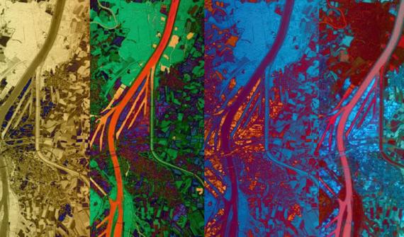
Ta: First track for me is global land cover map. So it's the Esri 2020 land cover, a 10 class global land use and land cover map for the year 2020 at 10 meter resolution across the globe.
Now following best practices for accuracy assessment, it really enabled the impact observatory to produce a 95-confidence interval for each acreage estimate. And this is fantastic because it provides users with a clearer picture of the accuracy and total area for each of the classes they’ll be accessing.
So in short, it's higher resolution, open, accurate, comparable, and it's timely. And do you know what the best part for me is?
Josh: Go on.
Ta: It’s created with AI.
Wayne: I know, isn't it great!
Ta: Yeah. It's produced by a deep learning model that's trained using over 5 billion hand labeled Sentinel two pixels, and they're sampled from over 20,000 sites distributed across all major biomes of the world.
Josh: That is pretty impressive. And just double check. Where do we find that? Where can we go use it?
Ta: It is a fantastic addition to the Living Atlas.
Josh: So ArcGIS Online right?
Ta: Yeah, ArcGIS Online.
Josh: Excellent.
Wayne: Definitely one of my favorites too, the machine learning aspect is what tips it over for me.
Josh: Alright Wayne, whatcha got?
Wayne: All right. What I've got is I've got an A side a B-side and a bonus track as well.
Josh: Go on. Go on.
Wayne: And I must say, first of all, that I picked up on a bit of a theme this year at the UC. And that theme is 3D, it seemed everything this year was showing up in 3D. All of its different guises. It's a little bit of a new addition to the Esri tool kit over the last couple of years, but it certainly seems to have been a big theme at the UC.
And my first track is in that theme, and it is the integration with the runtime game engine plugins. This is super cool.
Josh: Are you a gamer Wayne? Are you?
Wayne: I'm not a gamer. I'm definitely not a gamer.
Josh: I doubt you have time to be?
Wayne: I don't have time with all my machine learning and all the other stuff that crazy little Tiggers do.
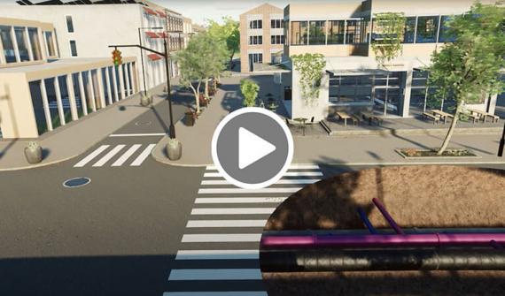
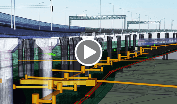
But, I do love this integration. I've seen a really, really good demonstration, you will have seen me post it on my LinkedIn, of a lovely French guy, giving a demo of augmented reality game engine integration with GIS data. And this is made possible through the runtime SDK game engine plugins.
The demonstration shows, using augmented reality on a mobile phone, to scan around the roads and the ground and actually show real utility networks underground where they actually exist. This is a game changer.
It's kind of like Dial Before You Dig on steroids.
Ta: Oh, wow. That's nice.
Josh: So Wayne. In beta right now that capability? So one for the future one to watch?
Wayne: In beta right now, but, certainly easily accessible. And if you're already familiar with the game engines, you can integrate that into your pipeline already.
Josh: That is really cool that, that demo was Bendigo wasn't it?
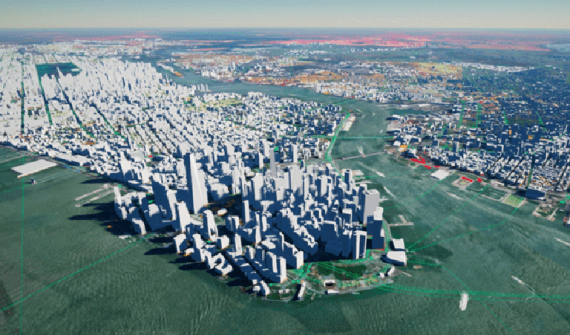
Wayne: They also did the Bendigo fly over, which was, uh, built using, uh, 3D meshes from our partner Aerometrex. And I think that was one of the most popular demonstrations there at the UC, flying right down to ground level and getting some really beautiful visualisations of Bendigo.
Josh: Very cool. No bonus tracks from me, just plain old two sides, and I'm going to kick off with an addition to ArcGIS Online, which is ArcGIS Image for ArcGIS Online.
Ta: Oh, very nice.
Josh: Yeah. And look, this is capability that I think could be classified as putting a lot of power in people's hands who might not have otherwise found that achievable.
Because managing imagery is innately difficult. There's typically a lot of infrastructure required, a lot of storage, a lot of IT stuff to make it all work for you. And what ArcGIS Image for ArcGIS Online does is let you do all of that in a SAS manner in the cloud and, recognising the fact that some folks will want to upload their imagery and process it and analyse it and create kind of derivative products from it.
So, I think that's going to be a really popular way for people to jump on image processing, where they might've been unable to do so before and to get it, it's just another user type extension in the same way the utility network is, the image user type extension for ArcGIS Online is how you get it.
Ta: Oh very cool.
Wayne: And so this is like the old image server, but up on the cloud, there for you yeah?
Josh: Yeah. So image server and raster analytics server, kinda of SAS. So yeah, nothing, nothing running in your data centre.
Wayne: No more pain of having to set up image server in raster analysis.
Josh: That's right? Where did we get to? Ta.
Ta: Okay. Next track DJ. And for this, I'm going to jump straight into instant apps. Now these are configurable apps re-imagined, they're quick, intuitive, configurable, and accessible. So quick and easy to build and to use. Best thing about this is no coding is required.
You just share your web map to the app that best suits your audience
Now, each app template has a specific purpose, which I find absolutely phenomenal, so you can view a map or a scene. You can compare content, you can get directions or explore a gallery of content and you can also find something that's nearby. And what's really cool for me is that when you have a map selected, Instant Apps analyses the content in your map, including popups and symbolisation and attachments. And it suggests what's compatible in terms of capability.
Josh: That sort of feels a bit like an extension of smart mapping doesn't it? You know, where the symbology and style is, suggested for you, but to do that with the actual app and its configuration, that's really good, that deserves a place on the record.
Ta: On the record, thank you so much.
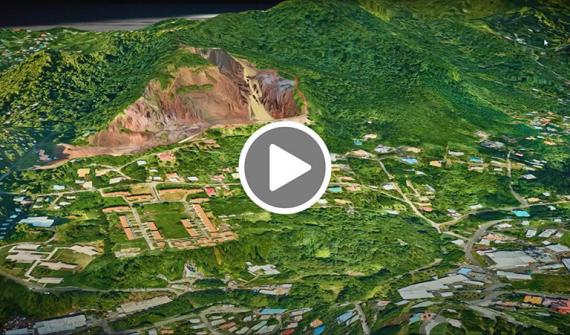
Wayne: My turn? All right. My second track is 3D reality caption, now this one kind of cross fades out of the runtime SDK game engine stuff. See what I did there, another music reference.
Josh: Yes!
Wayne: All right. Now this is about a product called a Site Scan and Site Scan for ArcGIS is the end-to-end cloud-based drone mapping software designed to revolutionise image collection and processing and analysis.
And this is how we capture reality, hence reality capture. We capture reality with our drone flights and build that into 3D meshes that can be instantly viewed within your 3D applications in ArcGIS, super cool. And it's where we're getting some of the best visualisations that we've seen throughout the UC.
I think even Jack mentions how much he loves the 3D mesh visualisations in his Plenary notes.
Josh: Is this the result of a recent acquisition or something that happened this year?
Wayne: Yeah. Totally is. Whilst it's not new it's got some new features and that includes a new processing engine that takes your 3D output and makes it even tastier than ever. Now this is called 'Sure for ArcGIS'. That's S U R E. And it did come out through the acquisition of nFrames and it's built with Esri proprietary software, and it produces highly detailed meshes with photo realistic looks, and you can look forward to more detail, more sharp edges and higher resolution in your textures, in your 3D meshes. So super sexy.
Ta: Very cool.
Josh: Okay, final track from me is one that we talked about, we actually had an episode dedicated to this, which is ArcGIS Enterprise on Kubernetes.
Wayne: Love it!
Ta: Yep.
Josh: Yeah. And look, it's worth bringing up again because it did get a lot of attention at the UC and that was warranted because it is a brand-new deployment option for ArcGIS Enterprise, joining Linux and Windows, the current flavors available to you.
But this is designed and developed specifically to be cloud native. So to take advantage of really contemporary IT strategies, infrastructure, and exemplary use of AWS Azure and other clouds as time goes on. Why bring it up again? Well, it's getting plenty of attention and it should be in people's minds when they're thinking about the future of how they use ArcGIS Enterprise.
It's not for everybody, but it's going to appeal to organisations who want to work with ArcGIS Enterprise at a grand scale., they want lots of flexibility about the way they deploy it. And they want to take advantage of the open-source goodness that comes with Kubernetes.
So, if that is a description of your organisation, then reach out and we can tell you more about that option.
Wayne: Exciting. I'm going to have to have a play.
Ta: Very cool. Okay. Bonus track.
Wayne: Play the track.
Ta: DJ spin them decks. Okay, for me, embedded maps and what's new MS teams and SAS Bridge for ArcGIS. Yeah.
Josh: Tell us more.
Ta: Now I love the tagline for this track, which is “better together”, because that means it's for everyone and that's what I'm all about.
Now there's ArcGIS for Office, which helps us to quickly and easily give spatial context to your data in Excel for example, maps for SharePoint, as well as Power BI, which includes spatial analysis for your Power BI and now maps for Teams.
Josh: So does that mean if we're chatting in Teams or in a meeting, you can flip me a map. You can send me... and we can kind of collaborate around it?
Ta: Yeah, yeah, absolutely. That's what it's built for. So you just, quickly, um, well once installed, you can just, search for maps in your content in Teams and then once you find it, you can add it to your meeting and you can, you know, start to collaborate and share, and it's one of the new additions to the ever expanding list of apps, which you can embed with web maps.
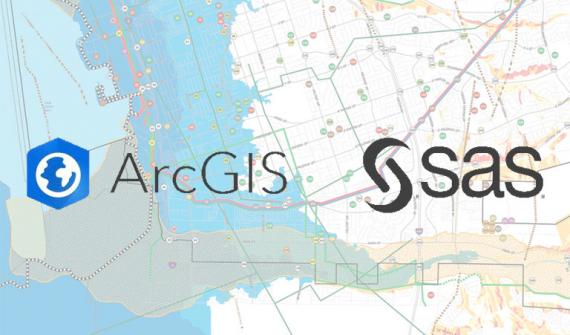
Now I mentioned an integration. So new integration with SAS which is similar to existing
R-Bridge. Now three must know things here, SAS is a statistical software suite with advanced data science capabilities, including machine learning tools.Now try say that three times fast statistical software suites. Now, this SAS ArcGIS bridge enables you to quickly convert data across SAS and ArcGIS Pro, go Pro, via geo processing tools or scripted via ArcPI or model builder or Notebooks. You know, again, a huge shout out for machine learning there. And finally, uh, the SAS ArcGIS Bridge also enables you to use SAS analysis procedures directly inside ArcGIS Pro, and the tools are available at all licensing levels with ArcGIS Pro 2.8 installation.
Josh: I like that Ta because it, it's kind of recognition in the same way that Notebooks and the open data science libraries. This recognises that SAS is a product that people use for a particular type of analysis, but bringing the two together and you get the best of both worlds.
Ta: I love how everything is just, it meshes together well, right? Like we have been looking at and talking about and using AI and machine learning and just as everything expands, you know, we really are integrating the world of spatial and data science.
Wayne: Exciting stuff.
Josh: One more in the wings from you Wayne?
Wayne: I do. I've got a bonus track. It's the last track on the album. You never put your best track at the end, but I think this is pretty cool. This is, um, cloud data warehouse support.
Josh: Oh okay, could be a goodie.
Wayne: Yeah, no, no. It's all right. Bear with me here. So, it's winter and we get snowflake support in insights.
Now what’s snowflake? It's another big data database or big data data service up in the cloud. And it's not just snowflake that we get support in insights. It's also coming to Pro and ArcGIS Enterprise. And it's not just snowflake. We get integration with Google Big Query. We get Amazon Redshift, we get Azure Sequel and a whole bunch of others as well.
Now, what's this all about? Well, what it's all about is that organisations are increasingly putting their data up in data warehouses up in the cloud. And if you're trying to pull some data into ArcGIS from the cloud data platforms that you've got it stored in, or integrate some data from, you know, ancient or unstructured formats, or if you're trying to embed maps into business workflows, applications like Salesforce or Service Now, then this is for you.
Because when you're trying to pull that data into your ArcGIS products, when your data lives far away from where you're trying to do the processing, that's a lot of data coming across the pipeline, and that's where our bottlenecks and our slowness becomes. Now, the way this works is tools such as Insights, because they're so data hungry, and instead of passing that data over the wire, which is when things get bogged down, of course.
Instead of passing it across the wire, this new integration takes your queries to where the data is. So we run the actual queries up there, right where the data is, data has doesn't have to move around so much and we get a much faster experience.
Now, if you want to think old school, think along the lines of, of query layers, Josh. Remember them?
Josh: Yeah. Layers defined by sequel, right?
Wayne: Absolutely. Yeah. So, this is kind of doing a query layer up in your big data providers. And you run the data queries up there rather than piping it all across the wire. And in short, what it lets you do is it let you query, visualise then publish maps and feature services, but it leaves the data where it is.
Ta: That’s awesome.
Josh: No, that's going to be a really powerful, I like it, that could be a surprise hit.
Wayne: It is a surprise hit that's why it's a bonus track.
So that's it folks, time to lift the needle off the vinyl and wrap up this express trip through the 2021 user conference. It's clear to me that, uh, it's been a year of lockdowns and those lockdowns have given the boffins over in Esri base camp, a bit of a chance to really knuckle down and produce some very cool stuff.
Ta: We'll build a playlist of all the tracks we talked about today and share it on our website. That's gisdirectionspodcast.com.au.
Wayne: Wonderful. Thanks for joining us. Stay spatial.
Josh: Until next time.
Ta: Happy mapping.
Disclaimer: The views and opinions expressed in this podcast are solely those of the hosts and do not necessarily represent the views or opinions of Esri Australia.