In this last instalment of my three-part blog on the development of a next-generation one-call solution, I explain how the new solution ensures data security and maintains audit trails to protect both asset and project owners.
Exposing spatial data dig by dig
Allowing users to integrate one call into their own GIS workflows was a key requirement of the new solution.
Many organisations are using digital mapping to share their work instructions and corporate asset information with their field workers, and one call information should be available as part of that.
An important requirement for asset owners is that asset data should only be made available for the area of a proposed dig site; not for the full extent to allow them to track who’s digging where and when.
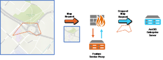
To achieve this, our solution included a proxy interface in front of the feature layer which required a unique enquiry token to be passed along with each request. This token is used to crop any feature queries to a maximum size of the original enquiry’s extent.
This ensures that an excavator wishing to view the data must first record their intent to dig and will only be shown data once for that dig area.
Keeping an audit trail of map views
Keeping a repository of the PDFs of maps that are sent out acts as an archive of the information that has been provided and for one call services, it’s an important audit trail in the case of a legal dispute arising from damage caused to an asset.
When asset data is provided through a digital map we have to take a different approach to this audit trail.
To be able to step back in time and view the map exactly as it was seen by the enquirer, we need to know what data was shown for the time of the enquiry, which must be linked to both a version of the data and a version of the representation (symbology) in use at the time of the enquiry.
We also keep an audit trail of the specific portions of the map that a user looked at when viewing the asset information.
Each time the user zoomed in or panned around, the application records the extent and scale to which that was done to show how the user interacted with the map. This allows the application to answer questions such as, “Did the user zoom in far enough to see all the detail?” or “Did they move around to see assets across the dig site?”
As well as recording how the maps embedded inside the POC solution are viewed, we also record queries against the GIS feature services in the case where users were viewing data on their own web map.
Open platform to drive innovation
I am a huge believer in the view that an open-platform will drive innovation as third-parties will come up with ideas you would have never dreamt of.
The platform model drives the Apple App Store where millions of developers are working on apps that could never have been developed by Apple alone.
When the US Weather Service opened their data for third-parties to develop on top of, it created a $5 billion-dollar industry in the use of meteorological data for a huge range of applications.
Australia’s one call technical solution is a closed-system and prohibits this style of innovation. For the next generation pilot, we adopted an open-platform approach, allowing the same underground asset and enquiry-response data to be extended by third-parties. This platform is designed to be a data broker enabling the discovery of asset owners and the sharing of their data.
As the data improves I can see machinery manufacturers building real-time integration into the cab, alerting the operator to nearby hazards or actively preventing the back-hoe from breaking earth when there’s a gas pipeline underneath.
Solutions for issuing permits can also be integrated into the enquiry-response process so that the lodgement of a dig response kicks off a permitting workflow with your preferred solution. Each part of the solution included web-hooks to allow for this style of open integration.
360-degree data sharing will see locators sharing the verified asset locations back to the utilities to assist in improving positional accuracy.
SmarterWX
As a by-product of the Next Generation one call pilot, Esri Australia has taken parts of the solution we developed and turned them into stand-alone products to support the existing members and enquirers of the existing 1100.com.au one-call service.
Extending our existing SmarterWX range of software-as-a-service solutions, SmarterWX Automate and SmarterWX Locate are both available as part of an early-access program with general availability planned for later this year.
SmarterWX Automate is your automated response service for asset owners needing to handle the enquiry referrals generated by 1100.com.au. A fully cloud-based service, Automate generates the asset plans and related documentation and returns them to the enquirer.
Built to integrate with your existing GIS investments, Automate synchronises with your existing asset data, removing the need for you to move data around.
For anyone who is making lots of one call enquiries, SmarterWX Locate takes away the pain of tracking the huge volume of emails that result.
Locate collates the responses as they are returned into a user-friendly web interface with just a single email notification to let you know when all the responses are ready. This is a great productivity tool for individuals and for sharing across your team.
Explore Gary's profile and more of his blogs here.
You can read the full series on the development of SmarterWX via our blog: Part I: Next-gen underground asset protection and Part II: Scalable solutions for underground asset protection.
To find out more about SmarterWX, visit the product page, call us on 1800 870 750 or send us an email.
Note: The views and opinions expressed in this article are those of the authors and do not necessarily reflect those of DBYD SA/NT or AADBYDS.