While open source is probably the interpretation of 'open' that attracts more media attention, interoperability, or the notion of an open platform, is typically of greater importance to most organisations.
Whether, and to what degree, IT vendors, their platforms and products are open is a topic that tends to solicit strong and often polarised opinion.
How heated the debate gets tends to depend on how the protagonists define ‘open’, and there are plenty of different ways to spin that term.
For a large software vendor like Esri, who needs to play in today's complex, heterogeneous enterprise IT environments, being open in multiple ways is an absolute necessity.
Specifically, in the context of the enterprise GIS space where Esri is operating, designing an interoperable, open platform is key.
To maximise the value of location intelligence across a business, information products and services that leverage spatial information need to surface through multiple channels.
The obvious manifestation of this is displaying a map in another enterprise business application, or perhaps a mobile app being used by a field worker.
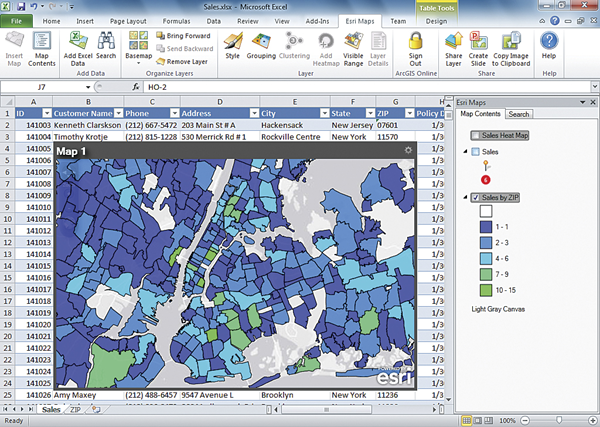
For example, a Microsoft Office user might use mapping capability from a GIS to visualise their data in Excel, and use that to help them make more informed decisions.
In the same vein, an SAP Work Manager user might access a map from a GIS to help orientate them in the field and locate nearby assets.
A less obvious and often overlooked channel for exploiting the power of a suitably open enterprise GIS platform is the integration of location intelligence into back-end business processes.
In this context, a business workflow includes one or more steps where a spatial question needs to be posed, and the answer to that question determines what happens next in the process.
A classic and very simple example of this would be the first interaction between a new customer and a call centre, where one of the first questions asked of the caller is probably, ‘Where do you live?’
The details provided by the caller can be injected into a business workflow that calls on a web service from the GIS, which turns the address into a location. That location can then drive several different outcomes.
One might be to show the operator where the caller is on a map, but perhaps, more importantly, it could also drive an analysis of their proximity to different significant resources. For example, their proximity to various risks would be very relevant to an insurer.
While detailed spatial analysis might be going on under the hood to answer that question, from the call centre operator's perspective, they just get an answer on their screen.
If you’re interested in finding out more about this type of GIS interoperability, have a look at part 1 and part 2 of this video series on location intelligence-driven business process management. I’ve also written a follow-up article that explains how you can achieve a greater level of interoperability.