With most coal and gas power stations slated for retirement over the next 15 years, Australia’s hills and mountains provide the ideal backdrop for a 100 per cent renewable solution.
3D GIS technology is helping a team from the Australian National University map a solution that could change the landscape of Australia’s energy future.
As Australia heads towards a looming energy crisis, the need for renewable, affordable energy has never been greater.
The Australian National University (ANU) Centre for Sustainable Energy Systems has found a solution that could eliminate Australia's need for coal and gas-fired power.
Professor Andrew Blakers from the ANU is leading a study to map potential short-term off-river pumped hydro energy storage (STORES) sites that could build a secure and cheap 100 per cent renewable Australian electricity grid.
The zero-emissions grid would mainly rely on wind and solar photovoltaic (PV) technology, with water pumped uphill and stored to generate electricity on demand.
“Water is pumped up from the low reservoir to the high reservoir when the sun shines and wind blows and electricity is abundant, then the water can run down through the turbine at night when electricity is expensive,” Professor Blakers said.
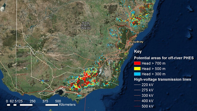
STORES sites are pairs of reservoirs, typically 10 hectares each, in hilly terrain, separated by an altitude of 300–900 metres, joined by a pipe pumping water in a closed loop. The sites consume little water and have a much smaller environmental impact that river-based systems.
Potential STORES locations are chosen based on a number of factors, including elevation, size, proximity to population centres and the surrounding landscape. The sites won’t intrude upon national parks and other protected land.
3D Geographic Information System (GIS) technology can detect and analyse these locations faster than any other method.
Members of the STORES team – Dr Matthew Stocks, Bin Lu and Kirsten Anderson – have partnered with Esri Australia, applying 3D technology to identify and map potential locations from North Queensland down the east coast to South Australia and Tasmania.
-
Digital Elevation Models are created from satellite data to conduct hydrological analysis for potential locations
-
A GIS technology platform processes, visualises, analyses, maps, explores and shares 3D datasets
-
3D analysis shows the water capacity and power potential of the dam sites
3D maps can be shared with the public, who can conduct their own analysis in the browser.
Esri CityEngine’s advanced 3D technology can also create realistic imagery, representing real-life features in a multidimensional view.
Capitalising on Australia’s abundance of wind and sun plus 3D GIS technology, the ANU Centre for Sustainable Energy Systems is at the forefront of finding a 100 per cent renewable solution for Australia’s energy crisis.
To find out more about 3D GIS technology, call 1800 870 750 or send us an email.