The release of ArcGIS Enterprise 10.6.1 includes new features in data management, mapping, analysis, collaboration and sharing, administration, faster performance and more.
From my perspective – as a consultant working with the platform daily – here is a countdown of my top 10 picks in the new release:
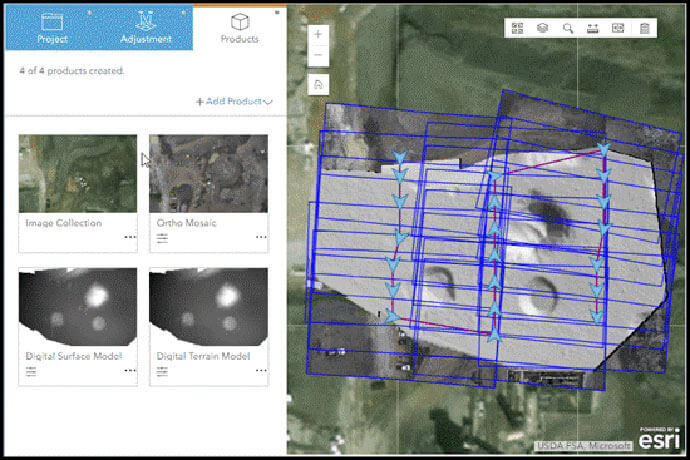
10. Leverage drone imagery
A lot of people are flying drones and gathering imagery to analyse data. The new web app, Ortho Maker helps you bring those drone images together to create orthoimage mosaics and terrain surface products. This is available in ArcGIS Enterprise via ArcGIS Image Server. Ortho Maker simplifies the time-intensive process of creating ortho-rectified imagery products from drone images. It is a three-step app that sets up the project, performs guided image adjustments, and generates an image collection.
9. Collaborate your apps
Apps built using Web AppBuilder and configurable app templates can now be shared to other ArcGIS Enterprise 10.6.1 deployments and to ArcGIS Online using Distributed Collaboration. Users who develop an app in one portal can share the app to another without rebuilding the app. For organisations with both ArcGIS Enterprise and ArcGIS Online that need to give access to the public or remote users, improved support for collaboration – through synchronisation of data, for example – makes the deployment of these mixed environments easier.
8. Map and feature service performance
Display performance of vector features has been improved in ArcGIS Enterprise 10.6.1 when consumed in the newest clients such as ArcGIS Pro 2.2 and the Map Viewer.
7. Run new feature analysis
There are three new tools in the Enterprise Portal that let you see data in different ways; analysis can now be done by all Online users, not just those with the ArcGIS Desktop applications. The Summarize Center and Dispersion tool measures the distribution of a set of features, calculating characteristics such as the centre or compactness and orientation. This can be used to track changes over time or compare distributions of different features. Find Centroids identifies the geometric centre of a multi-point line or area feature; Find Point Clusters locates clusters of point features based on their spatial distribution to help visualise significant concentration of points or events.
6. Display new symbology
The latest release includes new symbology for lines and points; arrows are available to indicate direction for line features such as rivers, roads, or tracks from time-enabled points. The bright firefly symbol set adds dimension and brightness to the layer. The predominant category and size styles can now compare up to 10 attributes, increasing the amount of data that can be compared.
5. Take vector tiles offline
Hosted vector tile base maps can now be taken offline through a checkbox, for use in offline apps and maps. Using the Vector Tile Replace Layer function you can also replace a hosted vector tile layer with an updated version without breaking the link between clients and apps using the layer. This makes life a lot easier not having to change all the URLs every time you update hosted vector tile layers. It’s a simple workflow – simply click the replace layer button, point to the layer you want to replace it with, click replace and it’s done. The URL stays the same and all the apps and maps are still happy.
4. Search and browse
The Gallery now includes a Date Modified filter that lets users quickly find content modified in the past day, week, month, or any custom range. Under the status filter, users can search for authoritative and deprecated items. Living Atlas content now has its own tab under Content, as well as its own categories such as boundaries, people, infrastructure and environment.
3. Item management
New in 10.6.1 is the option to assign items as authoritative or deprecated. An authoritative badge indicates the layer is recommended for use, while a deprecated badge indicates the layer is no longer kept up to date and therefore not recommended for new work. These badges help users to easily identify quality items. A new item information bar shows how much descriptive information an item has. This gauge helps promote quality data by encouraging users to add descriptions, such as a thumbnail, tags, longer description, or other item information. The more descriptors added, the more complete the bar.
2. Categorise your content
Content Categories helps you organise your content the way you want to, making it easier for people to find what they’re looking for. Content categories are organisational structures that reflect common themes in a deployment
And finally, here’s my number-one pick of the new release…
1. Create ArcGIS Enterprise Sites
The purpose of ArcGIS Enterprise Sites is to let administrators create a web page that makes their GIS data available to others, whether other departments internally or to the public (non-GIS users). You can configure and customise the look, feel and appearance of the web page – including banners, text, widgets, theme, header, footer. An out-of-the-box designer lets you use drag-and-drop functionality to edit settings, but you can also write HTML and CSS to fully customise the page as required.
This lets you organise relevant information around particular topics or departments so that others are able to easily access, interact with, and download data via these customised websites.
I hope you enjoy exploring all the new capabilities of this release. As always, let us know if you have any questions or comments about the updates or the platform in general. I’m looking forward to sharing my thoughts on upcoming release as they become available.
To find out more about any ArcGIS product, call a specialist on 1800 870 750 or send us an email.
Please note: if you are currently using Portal for ArcGIS with the Insights for ArcGIS app, please wait until Insights for ArcGIS 3.0 is released before upgrading to ArcGIS 10.6.1. The Insights 3.0 release expected to be available sometime around September 2018.