In 2018, the geospatial industry experienced an awesome year of technology advancements. Here Peter Gill has collated the collective insights of the highlights and trends for 2018 and 2019.
Several emerging technology capabilities and new product capabilities have been released over the last year that will have a significant impact on Geographic Information Systems (GIS) capabilities.
GIS is continuing to become mainstream for the consumer market and as a tier-one business system for all types of industries where location is at the heart of operations. It is accepted - actually expected - that a spatial map display is part of daily private lives and most business processes.
Here are some of the top outcomes for 2018 and insights for 2019.
1. Deploying Enterprise GIS Cloud Solutions
Cloud is increasingly becoming more central to business operations. The growth of geospatial solutions deployed in the Esri Australia Managed Cloud Services has exceeded expectations. However, the nature of geospatial data and technology constraints have traditionally been technical barriers for organisations to fully deploying their GIS business systems in the Cloud. These barriers are now being overcome and we are increasingly seeing organisations fully deploy their entire GIS Enterprise to the cloud. This is done through a combination of advances in cloud services capability and the improvements in how spatial data can be managed and used through web services.
Previously, key business datasets had to be maintained and analysed using desktop tools and direct connections to geodatabases. Such a scenario made cloud solutions prohibitive. As a Web GIS platform, ArcGIS technology increasingly allows editing, mapping and data analysis through web services, reducing the need for all the data to be in databases within a local area network. The 2018 release of the Utility Network Management Extension, showed that even complex data structures can be maintained exclusively via web services. This trend towards only using web services to access data will prevail. Moving forward, businesses should critically assess their data management processes and procedures, identifying opportunities to change their workflows from using direct database connections to using web services technologies, thereby removing barriers to migrating to the cloud.
2. GIS as a complete SaaS
ArcGIS Online (AGOL) has increasingly become a rich capable geospatial platform. Barriers to using GIS as a true Software as a Service (SaaS) platform are being removed. In December 2018, AGOL offered additional user types options as part of its subscription. Instead of just the Creator and Viewer user types, AGOL now offers three additional user types called Editor, Field Worker, and GIS Professional. These five user types are a combination of identity, capabilities and applications and is a more cost effective and better aligned with the user needs of an organisation.
In addition, the GIS Professional user type includes the license entitlement to run ArcGIS Pro, thereby providing a truly powerful capability to author and publish Web GIS content through a SaaS subscription.
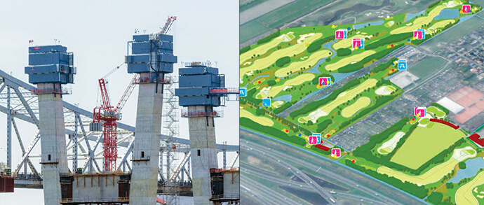
3. BIM with Virtual or Augmented Reality
There is a convergence of these technologies, with the demand for Building Information Models (BIM) to be intrinsically linked with GIS becoming increasingly prevalent. In 2018, Esri and Autodesk established a strategic alliance, establishing dataset and technology workflows that can seamlessly span location and design considerations. This is then tied in with the use of Virtual Reality (VR) or Augmented Reality (AR) technology that allows information to be visually relatable to the human mind.
These realities are accessible to end users through consumer level devices such as Microsoft HoloLens or simple VR goggles. For the lifecycle of construction projects the combination of these technologies will inform decision making, provide effective communication through visualisation to the public or key stakeholders and allow for more effective ongoing maintenance within the built environment.
4. Indoor navigation is “getting there”
The ability to navigate indoors is expected to take off. Consumers and business users want to get beyond the “You are here” static wall map display. The ability to use apps to do indoor wayfinding will soon be as easy as street navigation by using Esri ArcGIS Indoors. To get started involves loading in sites and floor plan data into an information model and accessing Indoor Positioning Systems (IPS) technology.
The product is planned to be released in March 2019 and business is getting excited about possible applications for corporate facilities, convention centres, educational campuses, retail stores and airports, to mention just a few. Mining companies are interested in being able to navigate mining sites, even underground. But indoors needs to be more than just wayfinding. Using ArcGIS Indoors will allow for improved safety and security management, asset and IT services management, allocation of indoor spaces and can be updated based on real-time events.

5. Big Data and IOT is allowing us to get smart
For the past few years everyone has been talking about big data and the Internet of Things (IOT). This will continue to gain momentum. The ability to display live sensor data, weather feeds, vehicle tracking information and data feeds over a map providing real-time situational awareness is still the GIS utopia.
This big data also opens a world of opportunity for analytics and machine learning with a huge amount of data that can be used to provide statistically significant insights never previously available.
In almost every industry, there are opportunities to be explored and the technology capability within the ArcGIS platform is constantly improving allowing sensor data to be more easily consumed, stored, queried and analysed. Capability through smart metering is now becoming common place, allowing utilities to manage supply and customers to manage their consumption. The question is how will you use this data?
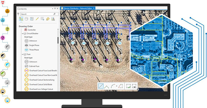
6. Creating a Digital Twin of Real-World Networks
Increasingly utility businesses want to have a complete digital twin of their real-world assets. This means each and every asset is recorded to the required level of detail and can be visualised in 3D or augmented reality. In the past the abstract spatial representation of a major asset (e.g. electrical substation) as a dot on a map was considered good enough. No more. With the 2018 release of the Utility Network Management Extension gas, water, electric and telcom (releasing 2019) utilities are able to have a complete digital record of their network assets.
Using concepts such as containment and association, the utility network data model can capture network features to any level of detail. The utility network is also 3D enabled, allowing the assets to be seamlessly visualised in a 3D map display. Taking this to the next level, this network data can then be accessible to field workers with an augmented reality digital twin display of assets.
7. Analytical tools for anyone
The lines between the GIS and Data Science are becoming increasingly blurred as advanced spatially enabled analytical tools become more accessible. Key products such as Insights for ArcGIS as a web-based, easy-to-use drag and drop data analytics workbench, is opening organisations to the opportunity to explore spatial and non-spatial data using maps, charts and tables leveraging advanced algorithmic spatial analysis tools.
This information is also easily accessible and digestible to a wider audience overcoming the view that GIS-enabled analytics is only something that can be done by a few specialists. Now anyone can start to ask a critical question and explore the data to find critical answers.
8. Rise of Machine Learning and Artificial Intelligence
Machine learning in the ArcGIS platform is taking analytics to the next level by allowing users to overcoming processes that are laborious and time-consuming or considered impossible to do manually. Machine learning capabilities within the ArcGIS Platform include classification, clustering and prediction, and the applications across business are extensive.
Out of the box, users have powerful machine learning capabilities, like raster analytical processing with distributed computing. Taking this to the next level, the ArcGIS Platform can integrate and leverage industry-standard Artificial Intelligence (AI) and platform libraries (e.g. IBM Watson or Python Scikit Learn). The typical process for a machine learning activity involves preparing the data, establishing the training model for the AI, running the model and then visualisation of the results. Key datasets in Australia are now accessible due to machine learning capabilities. For example, Geoscape data products provide rich building and tree coverage data for Australia, at a national scale, extracted and classified from over 200 terabytes of satellite imagery.
This list is just some of the highlights and more popular industry and technology trends.
Different technologies are important to different users. At a practical level, the breadth and depth of capabilities within the ArcGIS technologies seem to be unlimited. For every type of location, there is a trending geospatial technology that can beneficially impact our day to day lives.
To find out more about how the latest GIS technology could give your organisation the edge, contact a GIS consultant on 1800 870 750 or get in touch.